You are here: Home > Network List > CI - Caltech Regional Seismic Network Stations List
> Station RRX Rimrock Road, Barstow, CA, USA > Earthquake Result Viewer
RRX Rimrock Road, Barstow, CA, USA - Earthquake Result Viewer
| Earthquake location: |
Northern Peru |
| Earthquake latitude/longitude: |
-4.5/-76.1 |
| Earthquake time(UTC): |
2012/11/28 (333) 03:09:48 GMT |
| Earthquake Depth: |
118 km |
| Earthquake Magnitude: |
5.9 MB, 5.6 MW, 5.7 MW |
| Earthquake Catalog/Contributor: |
WHDF/NEIC |
|
| Network: |
CI Caltech Regional Seismic Network |
| Station: |
RRX Rimrock Road, Barstow, CA, USA |
| Lat/Lon: |
34.88 N/117.00 W |
| Elevation: |
439 m |
|
| Distance: |
54.9 deg |
| Az: |
318.858 deg |
| Baz: |
127.084 deg |
| Ray Param: |
0.06477214 |
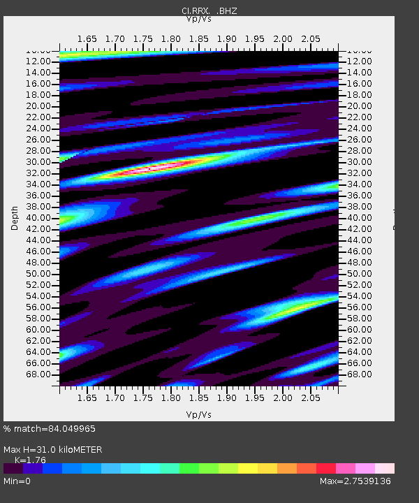
| Estimated Moho Depth: |
31.0 km |
| Estimated Crust Vp/Vs: |
1.76 |
| Assumed Crust Vp: |
6.276 km/s |
| Estimated Crust Vs: |
3.566 km/s |
| Estimated Crust Poisson's Ratio: |
0.26 |
|
| Radial Match: |
84.049965 % |
| Radial Bump: |
400 |
| Transverse Match: |
71.76757 % |
| Transverse Bump: |
400 |
| SOD ConfigId: |
486959 |
| Insert Time: |
2013-03-23 04:20:26.363 +0000 |
| GWidth: |
2.5 |
| Max Bumps: |
400 |
| Tol: |
0.001 |
|
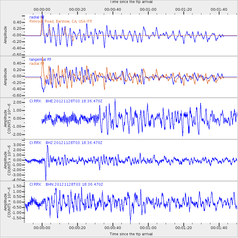
Signal To Noise
| Channel | StoN | STA | LTA |
| CI:RRX: :BHZ:20121128T03:18:36.470Z | 6.1072307 | 1.4458388E-6 | 2.3674215E-7 |
| CI:RRX: :BHN:20121128T03:18:36.470Z | 1.3841803 | 4.4217907E-7 | 3.194519E-7 |
| CI:RRX: :BHE:20121128T03:18:36.470Z | 2.119301 | 7.406111E-7 | 3.4946007E-7 |
| Arrivals |
| Ps | 3.9 SECOND |
| PpPs | 13 SECOND |
| PsPs/PpSs | 17 SECOND |


