You are here: Home > Network List > CB - China National Seismic Network Stations List
> Station HEH Heihe,Heilongjiang Province > Earthquake Result Viewer
HEH Heihe,Heilongjiang Province - Earthquake Result Viewer
| Earthquake location: |
Rat Islands, Aleutian Islands |
| Earthquake latitude/longitude: |
51.8/178.8 |
| Earthquake time(UTC): |
2014/06/23 (174) 20:53:09 GMT |
| Earthquake Depth: |
108 km |
| Earthquake Magnitude: |
7.9 MWW, 7.1 MI, 7.9 MWC |
| Earthquake Catalog/Contributor: |
NEIC PDE/NEIC COMCAT |
|
| Network: |
CB China National Seismic Network |
| Station: |
HEH Heihe,Heilongjiang Province |
| Lat/Lon: |
50.25 N/127.41 E |
| Elevation: |
165 m |
|
| Distance: |
31.8 deg |
| Az: |
287.899 deg |
| Baz: |
67.011 deg |
| Ray Param: |
0.078638814 |
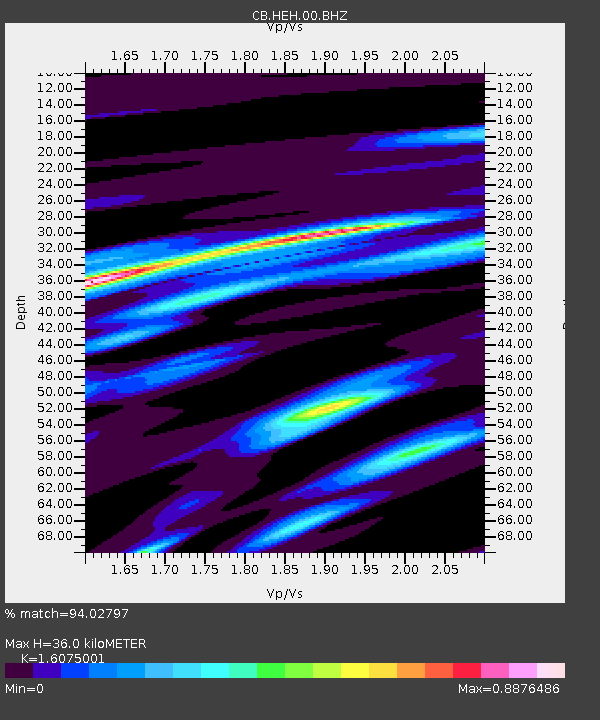
| Estimated Moho Depth: |
36.0 km |
| Estimated Crust Vp/Vs: |
1.61 |
| Assumed Crust Vp: |
6.419 km/s |
| Estimated Crust Vs: |
3.993 km/s |
| Estimated Crust Poisson's Ratio: |
0.18 |
|
| Radial Match: |
94.02797 % |
| Radial Bump: |
143 |
| Transverse Match: |
53.350845 % |
| Transverse Bump: |
307 |
| SOD ConfigId: |
3390531 |
| Insert Time: |
2019-04-12 10:24:27.775 +0000 |
| GWidth: |
2.5 |
| Max Bumps: |
400 |
| Tol: |
0.001 |
|
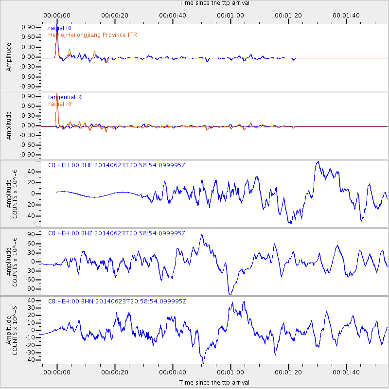
Signal To Noise
| Channel | StoN | STA | LTA |
| CB:HEH:00:BHZ:20140623T20:58:54.099995Z | 1.9698426 | 8.925097E-6 | 4.530868E-6 |
| CB:HEH:00:BHN:20140623T20:58:54.099995Z | 1.9382511 | 5.150348E-6 | 2.657214E-6 |
| CB:HEH:00:BHE:20140623T20:58:54.099995Z | 1.9430014 | 7.2040066E-6 | 3.7076693E-6 |
| Arrivals |
| Ps | 3.7 SECOND |
| PpPs | 13 SECOND |
| PsPs/PpSs | 17 SECOND |


