You are here: Home > Network List > TA - USArray Transportable Network (new EarthScope stations) Stations List
> Station J05D Fort Rock, OR, USA > Earthquake Result Viewer
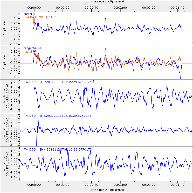
J05D Fort Rock, OR, USA - Earthquake Result Viewer
*The percent match for this event was below the threshold and hence no stack was calculated.
| Earthquake location: |
Northern Peru |
| Earthquake latitude/longitude: |
-4.5/-76.1 |
| Earthquake time(UTC): |
2012/11/28 (333) 03:09:48 GMT |
| Earthquake Depth: |
118 km |
| Earthquake Magnitude: |
5.9 MB, 5.6 MW, 5.7 MW |
| Earthquake Catalog/Contributor: |
WHDF/NEIC |
|
| Network: |
TA USArray Transportable Network (new EarthScope stations) |
| Station: |
J05D Fort Rock, OR, USA |
| Lat/Lon: |
43.28 N/121.23 W |
| Elevation: |
1541 m |
|
| Distance: |
62.6 deg |
| Az: |
324.344 deg |
| Baz: |
127.269 deg |
| Ray Param: |
$rayparam |
*The percent match for this event was below the threshold and hence was not used in the summary stack. |
|
| Radial Match: |
44.268894 % |
| Radial Bump: |
400 |
| Transverse Match: |
52.05879 % |
| Transverse Bump: |
400 |
| SOD ConfigId: |
486959 |
| Insert Time: |
2013-03-23 04:31:41.245 +0000 |
| GWidth: |
2.5 |
| Max Bumps: |
400 |
| Tol: |
0.001 |
|
Signal To Noise
| Channel | StoN | STA | LTA |
| TA:J05D: :BHZ:20121128T03:19:29.675017Z | 2.3359597 | 1.455834E-6 | 6.232274E-7 |
| TA:J05D: :BHN:20121128T03:19:29.675017Z | 0.56830484 | 3.5330424E-7 | 6.2168084E-7 |
| TA:J05D: :BHE:20121128T03:19:29.675017Z | 1.1883781 | 6.7100046E-7 | 5.646355E-7 |
| Arrivals |
| Ps | |
| PpPs | |
| PsPs/PpSs | |


