You are here: Home > Network List > KN - Kyrgyz Seismic Telemetry Network Stations List
> Station UCH - > Earthquake Result Viewer
UCH - - Earthquake Result Viewer

| Earthquake location: |
Rat Islands, Aleutian Islands |
| Earthquake latitude/longitude: |
51.8/178.8 |
| Earthquake time(UTC): |
2014/06/23 (174) 20:53:09 GMT |
| Earthquake Depth: |
108 km |
| Earthquake Magnitude: |
7.9 MWW, 7.1 MI, 7.9 MWC |
| Earthquake Catalog/Contributor: |
NEIC PDE/NEIC COMCAT |
|
| Network: |
KN Kyrgyz Seismic Telemetry Network |
| Station: |
UCH - |
| Lat/Lon: |
42.23 N/74.51 E |
| Elevation: |
3850 m |
|
| Distance: |
65.7 deg |
| Az: |
307.835 deg |
| Baz: |
41.327 deg |
| Ray Param: |
0.05780417 |
| Estimated Moho Depth: |
50.0 km |
| Estimated Crust Vp/Vs: |
1.78 |
| Assumed Crust Vp: |
6.306 km/s |
| Estimated Crust Vs: |
3.543 km/s |
| Estimated Crust Poisson's Ratio: |
0.27 |
|
| Radial Match: |
95.60494 % |
| Radial Bump: |
400 |
| Transverse Match: |
87.95469 % |
| Transverse Bump: |
400 |
| SOD ConfigId: |
3390531 |
| Insert Time: |
2019-04-12 10:26:31.941 +0000 |
| GWidth: |
2.5 |
| Max Bumps: |
400 |
| Tol: |
0.001 |
|
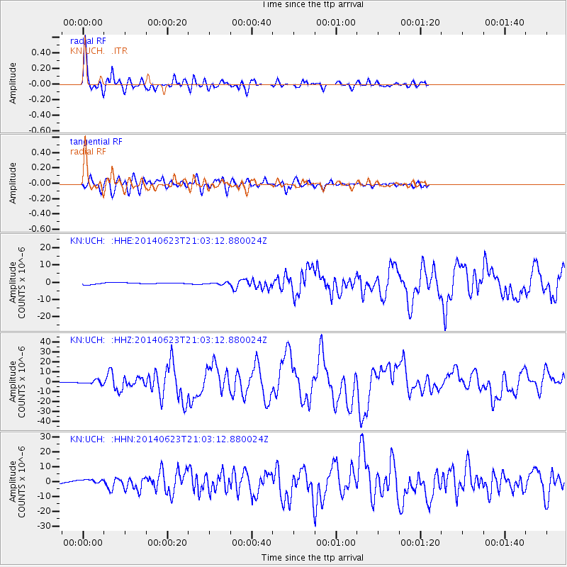
Signal To Noise
| Channel | StoN | STA | LTA |
| KN:UCH: :HHZ:20140623T21:03:12.880024Z | 6.9438224 | 1.9554466E-6 | 2.8160954E-7 |
| KN:UCH: :HHN:20140623T21:03:12.880024Z | 1.309803 | 1.860967E-6 | 1.4207992E-6 |
| KN:UCH: :HHE:20140623T21:03:12.880024Z | 1.2086713 | 5.256633E-7 | 4.3491008E-7 |
| Arrivals |
| Ps | 6.4 SECOND |
| PpPs | 21 SECOND |
| PsPs/PpSs | 28 SECOND |


