You are here: Home > Network List > TA - USArray Transportable Network (new EarthScope stations) Stations List
> Station Z41A Richland Creek Farm, El Dorado, AR, USA > Earthquake Result Viewer
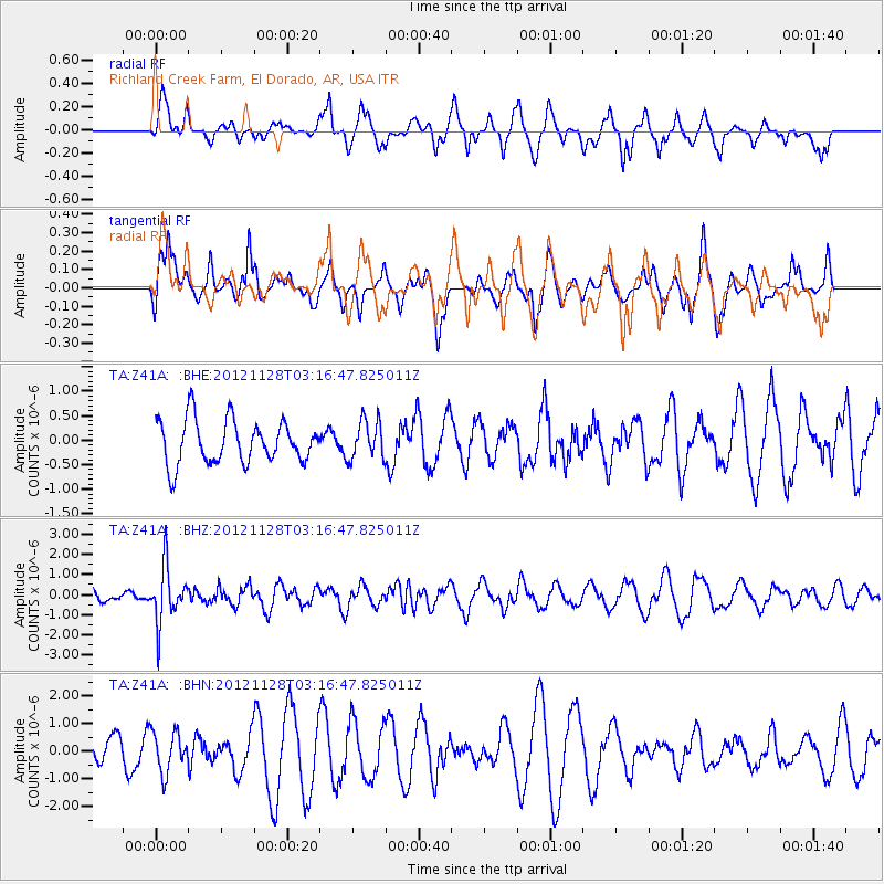
Z41A Richland Creek Farm, El Dorado, AR, USA - Earthquake Result Viewer
*The percent match for this event was below the threshold and hence no stack was calculated.
| Earthquake location: |
Northern Peru |
| Earthquake latitude/longitude: |
-4.5/-76.1 |
| Earthquake time(UTC): |
2012/11/28 (333) 03:09:48 GMT |
| Earthquake Depth: |
118 km |
| Earthquake Magnitude: |
5.9 MB, 5.6 MW, 5.7 MW |
| Earthquake Catalog/Contributor: |
WHDF/NEIC |
|
| Network: |
TA USArray Transportable Network (new EarthScope stations) |
| Station: |
Z41A Richland Creek Farm, El Dorado, AR, USA |
| Lat/Lon: |
33.26 N/92.80 W |
| Elevation: |
62 m |
|
| Distance: |
40.8 deg |
| Az: |
338.361 deg |
| Baz: |
153.976 deg |
| Ray Param: |
$rayparam |
*The percent match for this event was below the threshold and hence was not used in the summary stack. |
|
| Radial Match: |
60.210426 % |
| Radial Bump: |
354 |
| Transverse Match: |
57.23562 % |
| Transverse Bump: |
366 |
| SOD ConfigId: |
486959 |
| Insert Time: |
2013-03-23 04:34:31.892 +0000 |
| GWidth: |
2.5 |
| Max Bumps: |
400 |
| Tol: |
0.001 |
|
Signal To Noise
| Channel | StoN | STA | LTA |
| TA:Z41A: :BHZ:20121128T03:16:47.825011Z | 2.0643446 | 1.3882582E-6 | 6.724934E-7 |
| TA:Z41A: :BHN:20121128T03:16:47.825011Z | 1.3327279 | 7.277786E-7 | 5.4608194E-7 |
| TA:Z41A: :BHE:20121128T03:16:47.825011Z | 0.88851273 | 3.90928E-7 | 4.399802E-7 |
| Arrivals |
| Ps | |
| PpPs | |
| PsPs/PpSs | |


