You are here: Home > Network List > TA - USArray Transportable Network (new EarthScope stations) Stations List
> Station 348A Jackson, AL, USA > Earthquake Result Viewer
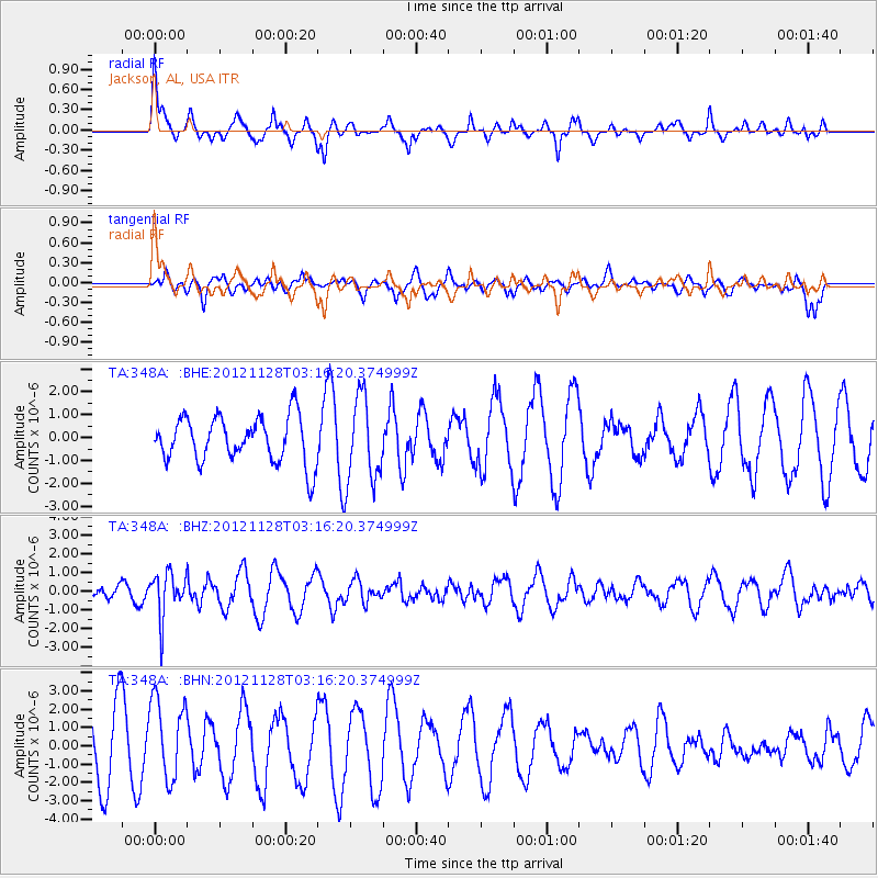
348A Jackson, AL, USA - Earthquake Result Viewer
*The percent match for this event was below the threshold and hence no stack was calculated.
| Earthquake location: |
Northern Peru |
| Earthquake latitude/longitude: |
-4.5/-76.1 |
| Earthquake time(UTC): |
2012/11/28 (333) 03:09:48 GMT |
| Earthquake Depth: |
118 km |
| Earthquake Magnitude: |
5.9 MB, 5.6 MW, 5.7 MW |
| Earthquake Catalog/Contributor: |
WHDF/NEIC |
|
| Network: |
TA USArray Transportable Network (new EarthScope stations) |
| Station: |
348A Jackson, AL, USA |
| Lat/Lon: |
31.41 N/87.90 W |
| Elevation: |
57 m |
|
| Distance: |
37.5 deg |
| Az: |
343.294 deg |
| Baz: |
160.416 deg |
| Ray Param: |
$rayparam |
*The percent match for this event was below the threshold and hence was not used in the summary stack. |
|
| Radial Match: |
54.368683 % |
| Radial Bump: |
378 |
| Transverse Match: |
62.41759 % |
| Transverse Bump: |
374 |
| SOD ConfigId: |
486959 |
| Insert Time: |
2013-03-23 04:35:30.639 +0000 |
| GWidth: |
2.5 |
| Max Bumps: |
400 |
| Tol: |
0.001 |
|
Signal To Noise
| Channel | StoN | STA | LTA |
| TA:348A: :BHZ:20121128T03:16:20.374999Z | 4.151411 | 1.192772E-6 | 2.8731725E-7 |
| TA:348A: :BHN:20121128T03:16:20.374999Z | 1.5281638 | 2.1950116E-6 | 1.436372E-6 |
| TA:348A: :BHE:20121128T03:16:20.374999Z | 1.8820658 | 1.8797735E-6 | 9.987821E-7 |
| Arrivals |
| Ps | |
| PpPs | |
| PsPs/PpSs | |


