You are here: Home > Network List > TA - USArray Transportable Network (new EarthScope stations) Stations List
> Station Y44A Strider, Charleston, MS, USA > Earthquake Result Viewer
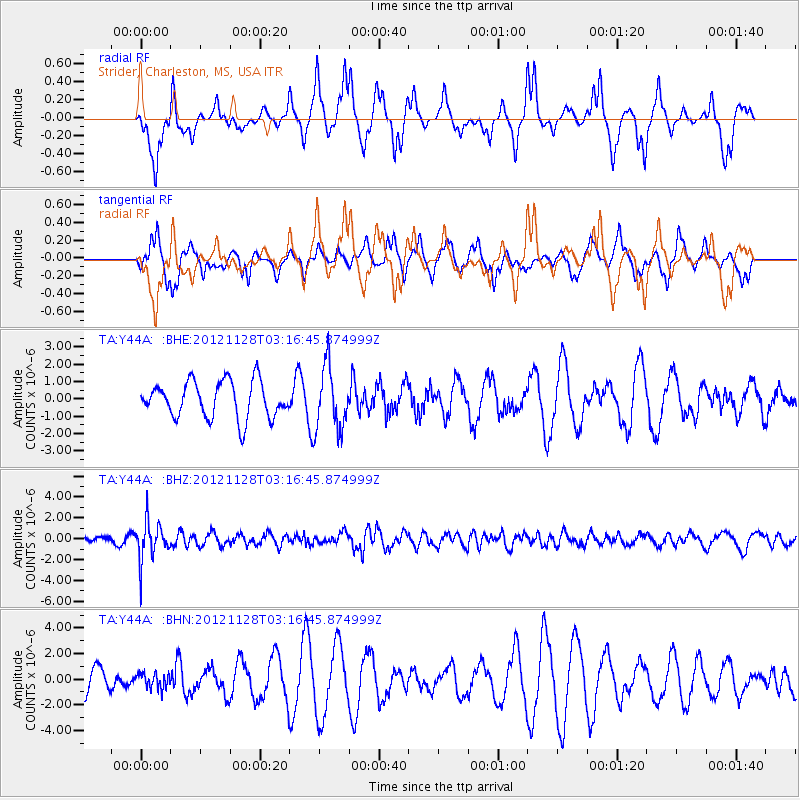
Y44A Strider, Charleston, MS, USA - Earthquake Result Viewer
*The percent match for this event was below the threshold and hence no stack was calculated.
| Earthquake location: |
Northern Peru |
| Earthquake latitude/longitude: |
-4.5/-76.1 |
| Earthquake time(UTC): |
2012/11/28 (333) 03:09:48 GMT |
| Earthquake Depth: |
118 km |
| Earthquake Magnitude: |
5.9 MB, 5.6 MW, 5.7 MW |
| Earthquake Catalog/Contributor: |
WHDF/NEIC |
|
| Network: |
TA USArray Transportable Network (new EarthScope stations) |
| Station: |
Y44A Strider, Charleston, MS, USA |
| Lat/Lon: |
33.96 N/90.21 W |
| Elevation: |
46 m |
|
| Distance: |
40.5 deg |
| Az: |
341.833 deg |
| Baz: |
158.039 deg |
| Ray Param: |
$rayparam |
*The percent match for this event was below the threshold and hence was not used in the summary stack. |
|
| Radial Match: |
44.848373 % |
| Radial Bump: |
289 |
| Transverse Match: |
55.43545 % |
| Transverse Bump: |
335 |
| SOD ConfigId: |
486959 |
| Insert Time: |
2013-03-23 04:36:37.764 +0000 |
| GWidth: |
2.5 |
| Max Bumps: |
400 |
| Tol: |
0.001 |
|
Signal To Noise
| Channel | StoN | STA | LTA |
| TA:Y44A: :BHZ:20121128T03:16:45.874999Z | 7.985197 | 1.8662257E-6 | 2.3371067E-7 |
| TA:Y44A: :BHN:20121128T03:16:45.874999Z | 0.4073805 | 5.971864E-7 | 1.465918E-6 |
| TA:Y44A: :BHE:20121128T03:16:45.874999Z | 1.7250245 | 1.8064729E-6 | 1.0472158E-6 |
| Arrivals |
| Ps | |
| PpPs | |
| PsPs/PpSs | |


