You are here: Home > Network List > TA - USArray Transportable Network (new EarthScope stations) Stations List
> Station V41A Mountainview, AR, USA > Earthquake Result Viewer
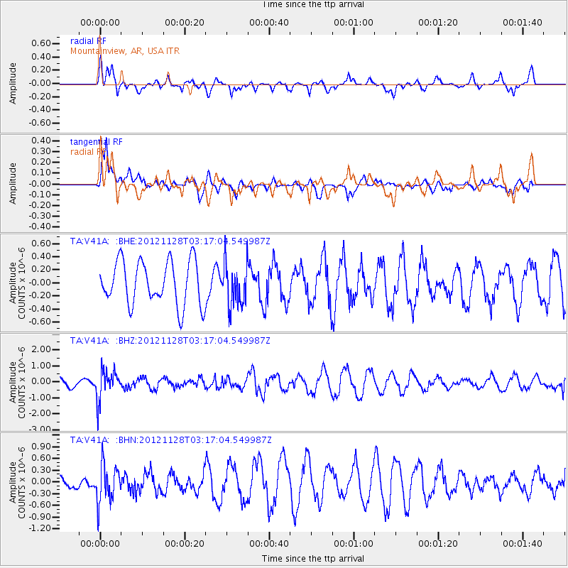
V41A Mountainview, AR, USA - Earthquake Result Viewer
*The percent match for this event was below the threshold and hence no stack was calculated.
| Earthquake location: |
Northern Peru |
| Earthquake latitude/longitude: |
-4.5/-76.1 |
| Earthquake time(UTC): |
2012/11/28 (333) 03:09:48 GMT |
| Earthquake Depth: |
118 km |
| Earthquake Magnitude: |
5.9 MB, 5.6 MW, 5.7 MW |
| Earthquake Catalog/Contributor: |
WHDF/NEIC |
|
| Network: |
TA USArray Transportable Network (new EarthScope stations) |
| Station: |
V41A Mountainview, AR, USA |
| Lat/Lon: |
35.79 N/92.16 W |
| Elevation: |
413 m |
|
| Distance: |
42.8 deg |
| Az: |
340.686 deg |
| Baz: |
156.075 deg |
| Ray Param: |
$rayparam |
*The percent match for this event was below the threshold and hence was not used in the summary stack. |
|
| Radial Match: |
49.76974 % |
| Radial Bump: |
398 |
| Transverse Match: |
67.23033 % |
| Transverse Bump: |
400 |
| SOD ConfigId: |
486959 |
| Insert Time: |
2013-03-23 04:37:57.892 +0000 |
| GWidth: |
2.5 |
| Max Bumps: |
400 |
| Tol: |
0.001 |
|
Signal To Noise
| Channel | StoN | STA | LTA |
| TA:V41A: :BHZ:20121128T03:17:04.549987Z | 3.5583565 | 9.3411415E-7 | 2.625128E-7 |
| TA:V41A: :BHN:20121128T03:17:04.549987Z | 1.6197761 | 4.9705636E-7 | 3.0686732E-7 |
| TA:V41A: :BHE:20121128T03:17:04.549987Z | 0.99660003 | 3.334772E-7 | 3.3461487E-7 |
| Arrivals |
| Ps | |
| PpPs | |
| PsPs/PpSs | |


