You are here: Home > Network List > TA - USArray Transportable Network (new EarthScope stations) Stations List
> Station TUL1 Leonard, OK, USA > Earthquake Result Viewer
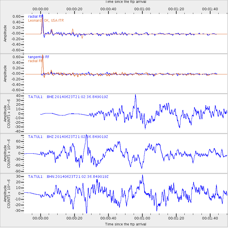
TUL1 Leonard, OK, USA - Earthquake Result Viewer
*The percent match for this event was below the threshold and hence no stack was calculated.
| Earthquake location: |
Rat Islands, Aleutian Islands |
| Earthquake latitude/longitude: |
51.8/178.8 |
| Earthquake time(UTC): |
2014/06/23 (174) 20:53:09 GMT |
| Earthquake Depth: |
108 km |
| Earthquake Magnitude: |
7.9 MWW, 7.1 MI, 7.9 MWC |
| Earthquake Catalog/Contributor: |
NEIC PDE/NEIC COMCAT |
|
| Network: |
TA USArray Transportable Network (new EarthScope stations) |
| Station: |
TUL1 Leonard, OK, USA |
| Lat/Lon: |
35.91 N/95.79 W |
| Elevation: |
256 m |
|
| Distance: |
60.2 deg |
| Az: |
68.908 deg |
| Baz: |
314.461 deg |
| Ray Param: |
$rayparam |
*The percent match for this event was below the threshold and hence was not used in the summary stack. |
|
| Radial Match: |
97.02011 % |
| Radial Bump: |
400 |
| Transverse Match: |
68.81938 % |
| Transverse Bump: |
400 |
| SOD ConfigId: |
3390531 |
| Insert Time: |
2019-04-12 10:29:17.490 +0000 |
| GWidth: |
2.5 |
| Max Bumps: |
400 |
| Tol: |
0.001 |
|
Signal To Noise
| Channel | StoN | STA | LTA |
| TA:TUL1: :BHZ:20140623T21:02:36.849019Z | 2.2396739 | 5.1404836E-6 | 2.2951929E-6 |
| TA:TUL1: :BHN:20140623T21:02:36.849019Z | 2.1428394 | 3.254468E-6 | 1.5187644E-6 |
| TA:TUL1: :BHE:20140623T21:02:36.849019Z | 1.863252 | 2.868624E-6 | 1.5395792E-6 |
| Arrivals |
| Ps | |
| PpPs | |
| PsPs/PpSs | |


