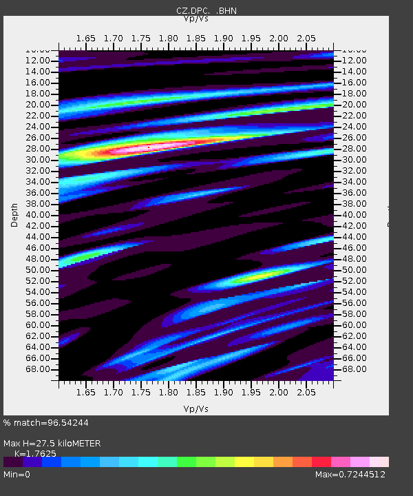
DPC Dobruska, Czech Republic - Earthquake Result Viewer
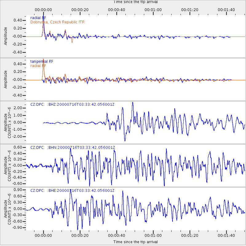
Earthquake location: Philippine Islands Region
Earthquake latitude/longitude: 20.3/122.0
Earthquake time(UTC): 2000/07/16 (198) 03:21:45 GMT
Earthquake Depth: 33 km
Earthquake Magnitude: 6.1 MB, 6.3 MS, 6.4 MW, 6.4 MW
Earthquake Catalog/Contributor: WHDF/NEIC
Network: CZ Czech Regional Seismic Network
Station: DPC Dobruska, Czech Republic
Lat/Lon: 50.36 N/16.41 E
Elevation: 760 m
Distance: 84.1 deg
Az: 321.678 deg
Baz: 65.362 deg
Ray Param: 0.045654494
Estimated Moho Depth: 27.5 km
Estimated Crust Vp/Vs: 1.76
Assumed Crust Vp: 6.194 km/s
Estimated Crust Vs: 3.514 km/s
Estimated Crust Poisson's Ratio: 0.26
Radial Match: 96.54244 %
Radial Bump: 400
Transverse Match: 87.95625 %
Transverse Bump: 400
SOD ConfigId: 3744
Insert Time: 2010-02-27 01:16:21.865 +0000
GWidth: 2.5
Max Bumps: 400
Tol: 0.001

Signal To Noise

ChannelStoNSTALTA
CZ:DPC: :BHN:20000716T03:33:42.056001Z0.678155543.2288117E-84.7611667E-8
CZ:DPC: :BHE:20000716T03:33:42.056001Z2.30299788.679145E-83.7686295E-8
CZ:DPC: :BHZ:20000716T03:33:42.056001Z5.8513083.1912558E-75.4539186E-8
Arrivals
Ps3.5 SECOND
PpPs12 SECOND
PsPs/PpSs15 SECOND