You are here: Home > Network List > TA - USArray Transportable Network (new EarthScope stations) Stations List
> Station G45A Suttons Bay, MI, USA > Earthquake Result Viewer
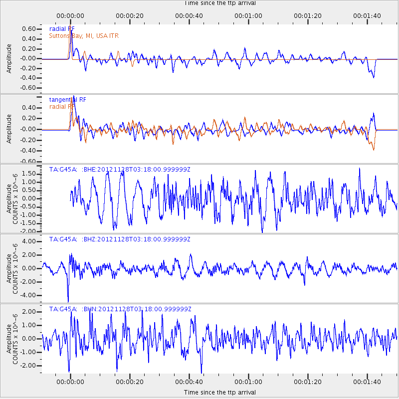
G45A Suttons Bay, MI, USA - Earthquake Result Viewer
*The percent match for this event was below the threshold and hence no stack was calculated.
| Earthquake location: |
Northern Peru |
| Earthquake latitude/longitude: |
-4.5/-76.1 |
| Earthquake time(UTC): |
2012/11/28 (333) 03:09:48 GMT |
| Earthquake Depth: |
118 km |
| Earthquake Magnitude: |
5.9 MB, 5.6 MW, 5.7 MW |
| Earthquake Catalog/Contributor: |
WHDF/NEIC |
|
| Network: |
TA USArray Transportable Network (new EarthScope stations) |
| Station: |
G45A Suttons Bay, MI, USA |
| Lat/Lon: |
45.04 N/85.66 W |
| Elevation: |
284 m |
|
| Distance: |
50.1 deg |
| Az: |
351.172 deg |
| Baz: |
167.537 deg |
| Ray Param: |
$rayparam |
*The percent match for this event was below the threshold and hence was not used in the summary stack. |
|
| Radial Match: |
46.9483 % |
| Radial Bump: |
400 |
| Transverse Match: |
75.66017 % |
| Transverse Bump: |
400 |
| SOD ConfigId: |
486959 |
| Insert Time: |
2013-03-23 05:04:33.881 +0000 |
| GWidth: |
2.5 |
| Max Bumps: |
400 |
| Tol: |
0.001 |
|
Signal To Noise
| Channel | StoN | STA | LTA |
| TA:G45A: :BHZ:20121128T03:18:00.999999Z | 2.2248464 | 1.5019984E-6 | 6.7510217E-7 |
| TA:G45A: :BHN:20121128T03:18:00.999999Z | 2.3237188 | 1.0833852E-6 | 4.6622907E-7 |
| TA:G45A: :BHE:20121128T03:18:00.999999Z | 0.84390587 | 7.7934186E-7 | 9.234938E-7 |
| Arrivals |
| Ps | |
| PpPs | |
| PsPs/PpSs | |


