You are here: Home > Network List > UW - Pacific Northwest Regional Seismic Network Stations List
> Station HOOD Mt Hood Meadows, OR CREST BB SMO > Earthquake Result Viewer
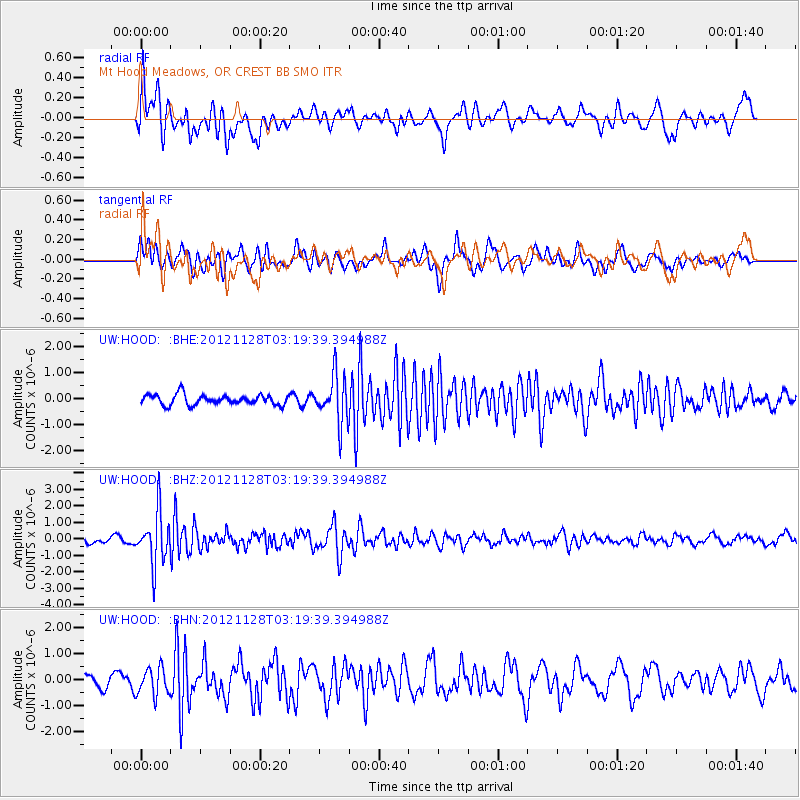
HOOD Mt Hood Meadows, OR CREST BB SMO - Earthquake Result Viewer
*The percent match for this event was below the threshold and hence no stack was calculated.
| Earthquake location: |
Northern Peru |
| Earthquake latitude/longitude: |
-4.5/-76.1 |
| Earthquake time(UTC): |
2012/11/28 (333) 03:09:48 GMT |
| Earthquake Depth: |
118 km |
| Earthquake Magnitude: |
5.9 MB, 5.6 MW, 5.7 MW |
| Earthquake Catalog/Contributor: |
WHDF/NEIC |
|
| Network: |
UW Pacific Northwest Regional Seismic Network |
| Station: |
HOOD Mt Hood Meadows, OR CREST BB SMO |
| Lat/Lon: |
45.32 N/121.65 W |
| Elevation: |
1520 m |
|
| Distance: |
64.1 deg |
| Az: |
325.947 deg |
| Baz: |
127.697 deg |
| Ray Param: |
$rayparam |
*The percent match for this event was below the threshold and hence was not used in the summary stack. |
|
| Radial Match: |
68.95632 % |
| Radial Bump: |
400 |
| Transverse Match: |
54.37261 % |
| Transverse Bump: |
386 |
| SOD ConfigId: |
486959 |
| Insert Time: |
2013-03-23 05:06:04.031 +0000 |
| GWidth: |
2.5 |
| Max Bumps: |
400 |
| Tol: |
0.001 |
|
Signal To Noise
| Channel | StoN | STA | LTA |
| UW:HOOD: :BHZ:20121128T03:19:39.394988Z | 6.9188266 | 1.5595173E-6 | 2.25402E-7 |
| UW:HOOD: :BHN:20121128T03:19:39.394988Z | 1.5226939 | 5.3099023E-7 | 3.4871766E-7 |
| UW:HOOD: :BHE:20121128T03:19:39.394988Z | 4.6617985 | 9.1278304E-7 | 1.9580062E-7 |
| Arrivals |
| Ps | |
| PpPs | |
| PsPs/PpSs | |


