You are here: Home > Network List > UW - Pacific Northwest Regional Seismic Network Stations List
> Station MRBL Marblemount, WA, USA > Earthquake Result Viewer
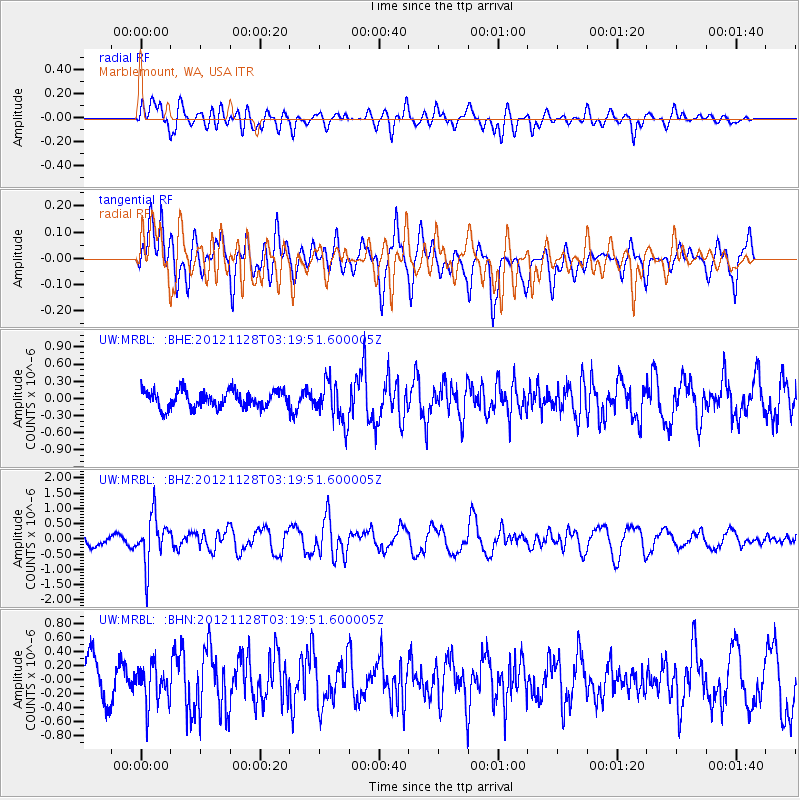
MRBL Marblemount, WA, USA - Earthquake Result Viewer
*The percent match for this event was below the threshold and hence no stack was calculated.
| Earthquake location: |
Northern Peru |
| Earthquake latitude/longitude: |
-4.5/-76.1 |
| Earthquake time(UTC): |
2012/11/28 (333) 03:09:48 GMT |
| Earthquake Depth: |
118 km |
| Earthquake Magnitude: |
5.9 MB, 5.6 MW, 5.7 MW |
| Earthquake Catalog/Contributor: |
WHDF/NEIC |
|
| Network: |
UW Pacific Northwest Regional Seismic Network |
| Station: |
MRBL Marblemount, WA, USA |
| Lat/Lon: |
48.52 N/121.48 W |
| Elevation: |
75 m |
|
| Distance: |
66.0 deg |
| Az: |
328.792 deg |
| Baz: |
129.021 deg |
| Ray Param: |
$rayparam |
*The percent match for this event was below the threshold and hence was not used in the summary stack. |
|
| Radial Match: |
75.71572 % |
| Radial Bump: |
400 |
| Transverse Match: |
61.531216 % |
| Transverse Bump: |
400 |
| SOD ConfigId: |
486959 |
| Insert Time: |
2013-03-23 05:06:18.282 +0000 |
| GWidth: |
2.5 |
| Max Bumps: |
400 |
| Tol: |
0.001 |
|
Signal To Noise
| Channel | StoN | STA | LTA |
| UW:MRBL: :BHZ:20121128T03:19:51.600005Z | 3.0214722 | 7.824442E-7 | 2.5896125E-7 |
| UW:MRBL: :BHN:20121128T03:19:51.600005Z | 0.7891765 | 2.6964426E-7 | 3.41678E-7 |
| UW:MRBL: :BHE:20121128T03:19:51.600005Z | 2.3519816 | 3.4649955E-7 | 1.4732238E-7 |
| Arrivals |
| Ps | |
| PpPs | |
| PsPs/PpSs | |


