You are here: Home > Network List > UW - Pacific Northwest Regional Seismic Network Stations List
> Station OMAK Colville Reservation, Omak, WA, USA > Earthquake Result Viewer
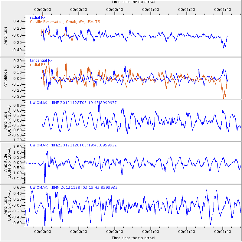
OMAK Colville Reservation, Omak, WA, USA - Earthquake Result Viewer
*The percent match for this event was below the threshold and hence no stack was calculated.
| Earthquake location: |
Northern Peru |
| Earthquake latitude/longitude: |
-4.5/-76.1 |
| Earthquake time(UTC): |
2012/11/28 (333) 03:09:48 GMT |
| Earthquake Depth: |
118 km |
| Earthquake Magnitude: |
5.9 MB, 5.6 MW, 5.7 MW |
| Earthquake Catalog/Contributor: |
WHDF/NEIC |
|
| Network: |
UW Pacific Northwest Regional Seismic Network |
| Station: |
OMAK Colville Reservation, Omak, WA, USA |
| Lat/Lon: |
48.36 N/119.33 W |
| Elevation: |
696 m |
|
| Distance: |
64.8 deg |
| Az: |
329.671 deg |
| Baz: |
130.992 deg |
| Ray Param: |
$rayparam |
*The percent match for this event was below the threshold and hence was not used in the summary stack. |
|
| Radial Match: |
53.848804 % |
| Radial Bump: |
400 |
| Transverse Match: |
60.997467 % |
| Transverse Bump: |
400 |
| SOD ConfigId: |
486959 |
| Insert Time: |
2013-03-23 05:06:18.679 +0000 |
| GWidth: |
2.5 |
| Max Bumps: |
400 |
| Tol: |
0.001 |
|
Signal To Noise
| Channel | StoN | STA | LTA |
| UW:OMAK: :BHZ:20121128T03:19:43.899993Z | 2.336392 | 7.090845E-7 | 3.034955E-7 |
| UW:OMAK: :BHN:20121128T03:19:43.899993Z | 1.1287614 | 2.9703713E-7 | 2.6315317E-7 |
| UW:OMAK: :BHE:20121128T03:19:43.899993Z | 1.3044971 | 4.6429773E-7 | 3.5592086E-7 |
| Arrivals |
| Ps | |
| PpPs | |
| PsPs/PpSs | |


