You are here: Home > Network List > UW - Pacific Northwest Regional Seismic Network Stations List
> Station IZEE Izee, OR, USA > Earthquake Result Viewer
IZEE Izee, OR, USA - Earthquake Result Viewer
| Earthquake location: |
Northern Peru |
| Earthquake latitude/longitude: |
-4.5/-76.1 |
| Earthquake time(UTC): |
2012/11/28 (333) 03:09:48 GMT |
| Earthquake Depth: |
118 km |
| Earthquake Magnitude: |
5.9 MB, 5.6 MW, 5.7 MW |
| Earthquake Catalog/Contributor: |
WHDF/NEIC |
|
| Network: |
UW Pacific Northwest Regional Seismic Network |
| Station: |
IZEE Izee, OR, USA |
| Lat/Lon: |
44.08 N/119.50 W |
| Elevation: |
1293 m |
|
| Distance: |
62.1 deg |
| Az: |
325.927 deg |
| Baz: |
129.195 deg |
| Ray Param: |
0.06009874 |
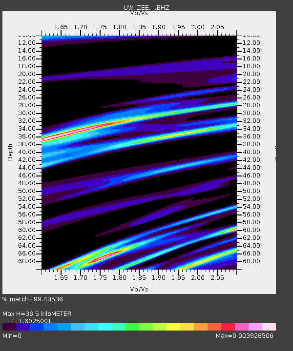
| Estimated Moho Depth: |
36.5 km |
| Estimated Crust Vp/Vs: |
1.60 |
| Assumed Crust Vp: |
6.571 km/s |
| Estimated Crust Vs: |
4.1 km/s |
| Estimated Crust Poisson's Ratio: |
0.18 |
|
| Radial Match: |
99.48536 % |
| Radial Bump: |
52 |
| Transverse Match: |
98.437805 % |
| Transverse Bump: |
235 |
| SOD ConfigId: |
486959 |
| Insert Time: |
2013-03-23 05:06:57.483 +0000 |
| GWidth: |
2.5 |
| Max Bumps: |
400 |
| Tol: |
0.001 |
|

Signal To Noise
| Channel | StoN | STA | LTA |
| UW:IZEE: :BHZ:20121128T03:19:26.399993Z | 4.848513 | 7.369802E-7 | 1.5200128E-7 |
| UW:IZEE: :BHN:20121128T03:19:26.399993Z | 1.0653305 | 3.1737784E-8 | 2.9791492E-8 |
| UW:IZEE: :BHE:20121128T03:19:26.399993Z | 4.983187 | 1.0084837E-6 | 2.0237725E-7 |
| Arrivals |
| Ps | 3.5 SECOND |
| PpPs | 14 SECOND |
| PsPs/PpSs | 17 SECOND |


