You are here: Home > Network List > CZ - Czech Regional Seismic Network Stations List
> Station DPC Dobruska, Czech Republic > Earthquake Result Viewer
DPC Dobruska, Czech Republic - Earthquake Result Viewer
| Earthquake location: |
Kuril Islands |
| Earthquake latitude/longitude: |
43.8/147.2 |
| Earthquake time(UTC): |
2000/08/19 (232) 17:26:27 GMT |
| Earthquake Depth: |
62 km |
| Earthquake Magnitude: |
6.0 MB, 5.8 MW, 5.7 MW |
| Earthquake Catalog/Contributor: |
WHDF/NEIC |
|
| Network: |
CZ Czech Regional Seismic Network |
| Station: |
DPC Dobruska, Czech Republic |
| Lat/Lon: |
50.36 N/16.41 E |
| Elevation: |
760 m |
|
| Distance: |
76.9 deg |
| Az: |
330.118 deg |
| Baz: |
34.267 deg |
| Ray Param: |
0.05057747 |
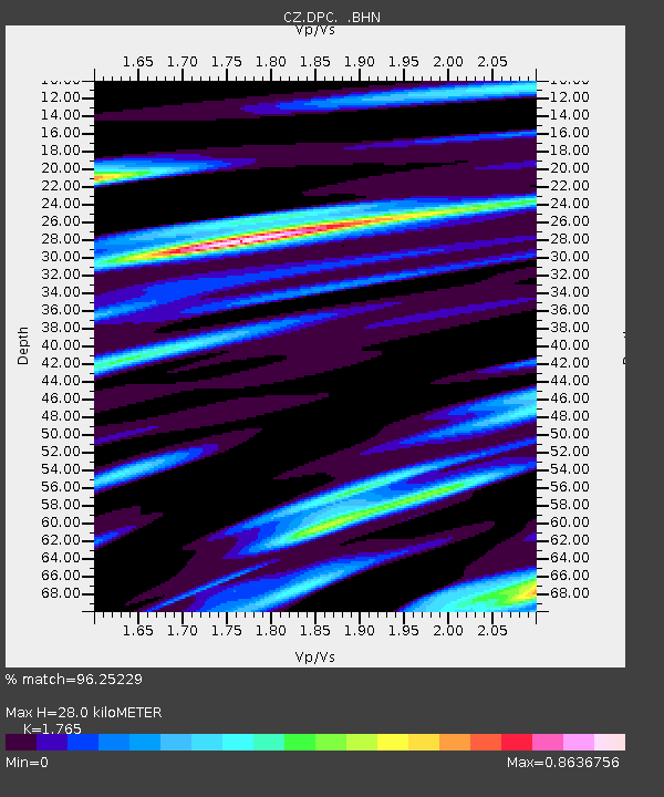
| Estimated Moho Depth: |
28.0 km |
| Estimated Crust Vp/Vs: |
1.76 |
| Assumed Crust Vp: |
6.194 km/s |
| Estimated Crust Vs: |
3.509 km/s |
| Estimated Crust Poisson's Ratio: |
0.26 |
|
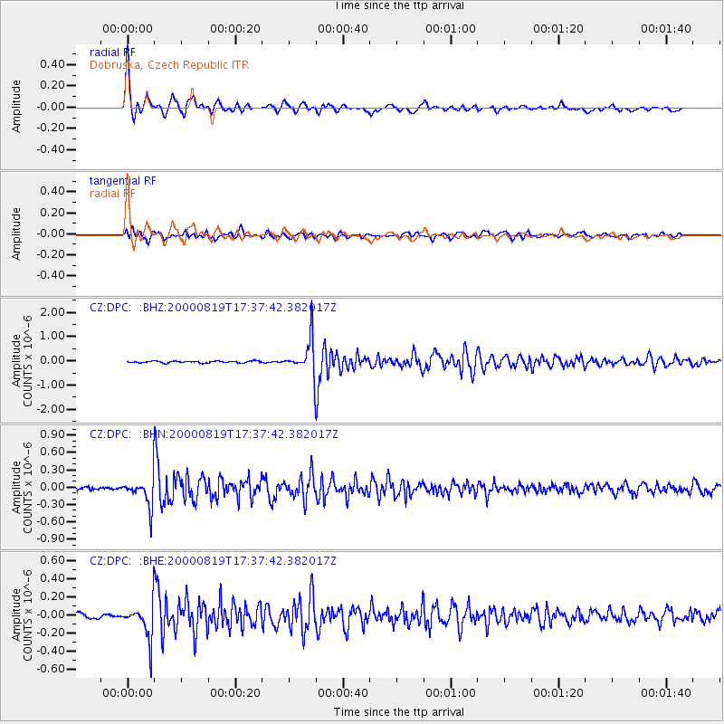
| Radial Match: |
96.25229 % |
| Radial Bump: |
400 |
| Transverse Match: |
86.762085 % |
| Transverse Bump: |
400 |
| SOD ConfigId: |
3744 |
| Insert Time: |
2010-02-27 01:16:40.541 +0000 |
| GWidth: |
2.5 |
| Max Bumps: |
400 |
| Tol: |
0.001 |
|
Signal To Noise
| Channel | StoN | STA | LTA |
| CZ:DPC: :BHN:20000819T17:37:42.382017Z | 9.659793 | 2.398881E-7 | 2.4833671E-8 |
| CZ:DPC: :BHE:20000819T17:37:42.382017Z | 7.22783 | 1.9827962E-7 | 2.7432801E-8 |
| CZ:DPC: :BHZ:20000819T17:37:42.382017Z | 18.394043 | 6.8871026E-7 | 3.7442028E-8 |
| Arrivals |
| Ps | 3.6 SECOND |
| PpPs | 12 SECOND |
| PsPs/PpSs | 16 SECOND |


