You are here: Home > Network List > G - GEOSCOPE Stations List
> Station SANVU Espiritu Santo, Vanuatu > Earthquake Result Viewer
SANVU Espiritu Santo, Vanuatu - Earthquake Result Viewer
| Earthquake location: |
Banda Sea |
| Earthquake latitude/longitude: |
-5.4/131.1 |
| Earthquake time(UTC): |
2012/11/28 (333) 08:56:16 GMT |
| Earthquake Depth: |
50 km |
| Earthquake Magnitude: |
5.9 MB, 5.2 MS, 5.6 MW, 5.6 MW |
| Earthquake Catalog/Contributor: |
WHDF/NEIC |
|
| Network: |
G GEOSCOPE |
| Station: |
SANVU Espiritu Santo, Vanuatu |
| Lat/Lon: |
15.45 S/167.20 E |
| Elevation: |
56 m |
|
| Distance: |
36.8 deg |
| Az: |
108.565 deg |
| Baz: |
281.841 deg |
| Ray Param: |
0.07636093 |
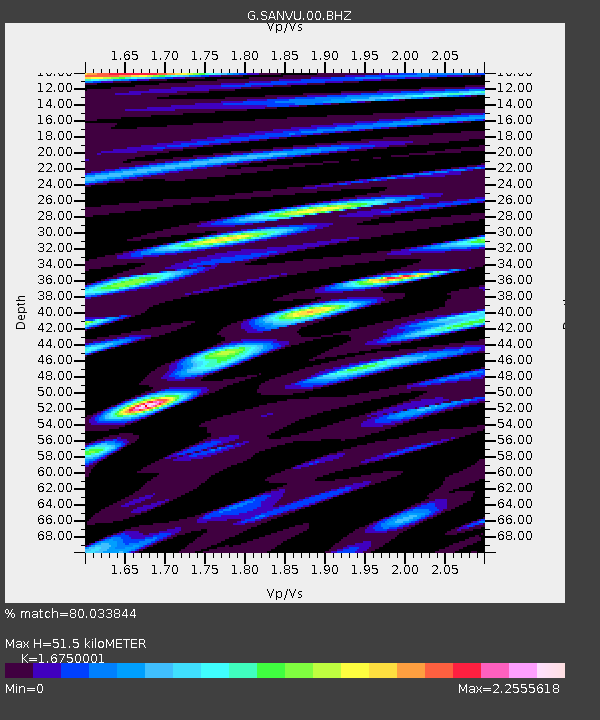
| Estimated Moho Depth: |
51.5 km |
| Estimated Crust Vp/Vs: |
1.68 |
| Assumed Crust Vp: |
4.802 km/s |
| Estimated Crust Vs: |
2.867 km/s |
| Estimated Crust Poisson's Ratio: |
0.22 |
|
| Radial Match: |
80.033844 % |
| Radial Bump: |
400 |
| Transverse Match: |
76.41226 % |
| Transverse Bump: |
400 |
| SOD ConfigId: |
486959 |
| Insert Time: |
2013-03-23 05:12:40.319 +0000 |
| GWidth: |
2.5 |
| Max Bumps: |
400 |
| Tol: |
0.001 |
|

Signal To Noise
| Channel | StoN | STA | LTA |
| G:SANVU:00:BHZ:20121128T09:02:48.799987Z | 2.73088 | 6.9842423E-7 | 2.5575062E-7 |
| G:SANVU:00:BHN:20121128T09:02:48.799987Z | 1.2140853 | 3.3157298E-7 | 2.7310517E-7 |
| G:SANVU:00:BHE:20121128T09:02:48.799987Z | 1.9384886 | 4.6267658E-7 | 2.3867904E-7 |
| Arrivals |
| Ps | 7.6 SECOND |
| PpPs | 28 SECOND |
| PsPs/PpSs | 35 SECOND |


