You are here: Home > Network List > TA - USArray Transportable Network (new EarthScope stations) Stations List
> Station L40A Anamosa, IA, USA > Earthquake Result Viewer
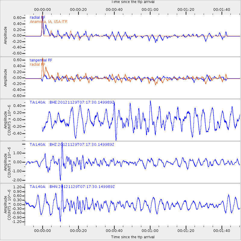
L40A Anamosa, IA, USA - Earthquake Result Viewer
*The percent match for this event was below the threshold and hence no stack was calculated.
| Earthquake location: |
Near Coast Of Northern Peru |
| Earthquake latitude/longitude: |
-6.6/-81.1 |
| Earthquake time(UTC): |
2012/11/29 (334) 07:09:12 GMT |
| Earthquake Depth: |
10 km |
| Earthquake Magnitude: |
5.5 MB, 4.9 MS, 5.5 MW, 5.4 MW |
| Earthquake Catalog/Contributor: |
WHDF/NEIC |
|
| Network: |
TA USArray Transportable Network (new EarthScope stations) |
| Station: |
L40A Anamosa, IA, USA |
| Lat/Lon: |
42.06 N/91.22 W |
| Elevation: |
242 m |
|
| Distance: |
49.3 deg |
| Az: |
350.03 deg |
| Baz: |
166.645 deg |
| Ray Param: |
$rayparam |
*The percent match for this event was below the threshold and hence was not used in the summary stack. |
|
| Radial Match: |
58.604122 % |
| Radial Bump: |
320 |
| Transverse Match: |
44.110497 % |
| Transverse Bump: |
382 |
| SOD ConfigId: |
486959 |
| Insert Time: |
2013-03-23 05:23:15.505 +0000 |
| GWidth: |
2.5 |
| Max Bumps: |
400 |
| Tol: |
0.001 |
|
Signal To Noise
| Channel | StoN | STA | LTA |
| TA:L40A: :BHZ:20121129T07:17:30.149989Z | 3.0212245 | 5.584908E-7 | 1.8485576E-7 |
| TA:L40A: :BHN:20121129T07:17:30.149989Z | 3.100828 | 4.532836E-7 | 1.4618148E-7 |
| TA:L40A: :BHE:20121129T07:17:30.149989Z | 0.5764206 | 1.17044316E-7 | 2.0305366E-7 |
| Arrivals |
| Ps | |
| PpPs | |
| PsPs/PpSs | |


