You are here: Home > Network List > YB13 - Continental Dynamics/Cent. Anatolian Tectonics:Surface to Mantle Dynamics During Stations List
> Station AT31 Inalli,Nevsehir,Turkey > Earthquake Result Viewer
AT31 Inalli,Nevsehir,Turkey - Earthquake Result Viewer
| Earthquake location: |
Rat Islands, Aleutian Islands |
| Earthquake latitude/longitude: |
51.8/178.8 |
| Earthquake time(UTC): |
2014/06/23 (174) 20:53:09 GMT |
| Earthquake Depth: |
108 km |
| Earthquake Magnitude: |
7.9 MWW, 7.1 MI, 7.9 MWC |
| Earthquake Catalog/Contributor: |
NEIC PDE/NEIC COMCAT |
|
| Network: |
YB Continental Dynamics/Cent. Anatolian Tectonics:Surface to Mantle Dynamics During |
| Station: |
AT31 Inalli,Nevsehir,Turkey |
| Lat/Lon: |
38.57 N/34.51 E |
| Elevation: |
1303 m |
|
| Distance: |
84.7 deg |
| Az: |
332.621 deg |
| Baz: |
21.367 deg |
| Ray Param: |
0.045029964 |
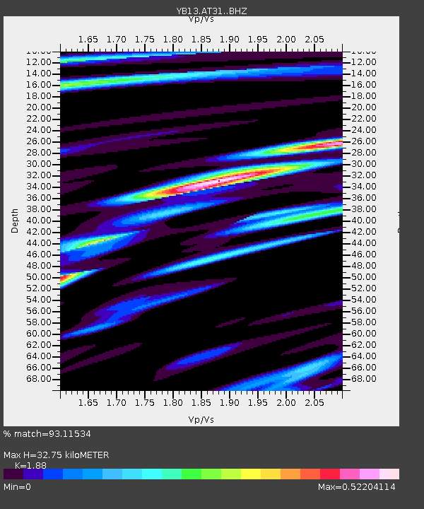
| Estimated Moho Depth: |
32.75 km |
| Estimated Crust Vp/Vs: |
1.88 |
| Assumed Crust Vp: |
6.35 km/s |
| Estimated Crust Vs: |
3.378 km/s |
| Estimated Crust Poisson's Ratio: |
0.30 |
|
| Radial Match: |
93.11534 % |
| Radial Bump: |
344 |
| Transverse Match: |
82.867966 % |
| Transverse Bump: |
400 |
| SOD ConfigId: |
3390531 |
| Insert Time: |
2019-04-12 10:32:21.753 +0000 |
| GWidth: |
2.5 |
| Max Bumps: |
400 |
| Tol: |
0.001 |
|

Signal To Noise
| Channel | StoN | STA | LTA |
| YB:AT31: :BHZ:20140623T21:05:01.800007Z | 1.8111992 | 3.8895955E-6 | 2.1475248E-6 |
| YB:AT31: :BHN:20140623T21:05:01.800007Z | 4.272118 | 7.0950483E-7 | 1.66078E-7 |
| YB:AT31: :BHE:20140623T21:05:01.800007Z | 1.1635512 | 1.7499318E-6 | 1.5039577E-6 |
| Arrivals |
| Ps | 4.6 SECOND |
| PpPs | 15 SECOND |
| PsPs/PpSs | 19 SECOND |


