You are here: Home > Network List > TA - USArray Transportable Network (new EarthScope stations) Stations List
> Station BGNE Belgrade, NE, USA > Earthquake Result Viewer
BGNE Belgrade, NE, USA - Earthquake Result Viewer
| Earthquake location: |
Tonga Islands |
| Earthquake latitude/longitude: |
-18.8/-175.6 |
| Earthquake time(UTC): |
2012/11/30 (335) 11:20:38 GMT |
| Earthquake Depth: |
200 km |
| Earthquake Magnitude: |
5.7 MW, 5.1 MB, 5.7 MW |
| Earthquake Catalog/Contributor: |
WHDF/NEIC |
|
| Network: |
TA USArray Transportable Network (new EarthScope stations) |
| Station: |
BGNE Belgrade, NE, USA |
| Lat/Lon: |
41.41 N/98.15 W |
| Elevation: |
573 m |
|
| Distance: |
93.2 deg |
| Az: |
47.341 deg |
| Baz: |
247.82 deg |
| Ray Param: |
0.041180454 |
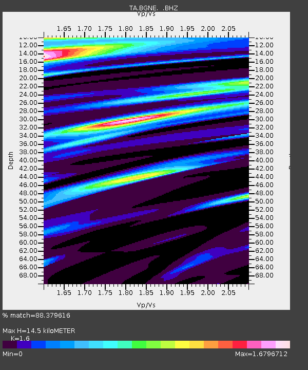
| Estimated Moho Depth: |
14.5 km |
| Estimated Crust Vp/Vs: |
1.60 |
| Assumed Crust Vp: |
6.53 km/s |
| Estimated Crust Vs: |
4.082 km/s |
| Estimated Crust Poisson's Ratio: |
0.18 |
|
| Radial Match: |
88.379616 % |
| Radial Bump: |
400 |
| Transverse Match: |
52.577324 % |
| Transverse Bump: |
400 |
| SOD ConfigId: |
486959 |
| Insert Time: |
2013-03-23 05:44:47.828 +0000 |
| GWidth: |
2.5 |
| Max Bumps: |
400 |
| Tol: |
0.001 |
|

Signal To Noise
| Channel | StoN | STA | LTA |
| TA:BGNE: :BHZ:20121130T11:32:58.674995Z | 1.5649508 | 8.930162E-7 | 5.706353E-7 |
| TA:BGNE: :BHN:20121130T11:32:58.674995Z | 0.50895137 | 4.4039575E-7 | 8.6530025E-7 |
| TA:BGNE: :BHE:20121130T11:32:58.674995Z | 1.4630975 | 1.2912118E-6 | 8.825193E-7 |
| Arrivals |
| Ps | 1.4 SECOND |
| PpPs | 5.6 SECOND |
| PsPs/PpSs | 7.0 SECOND |


