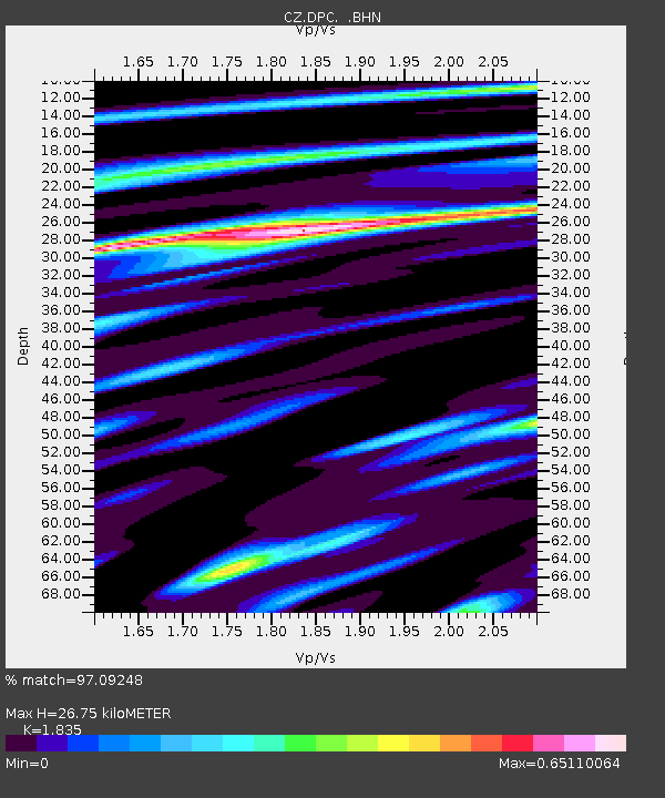
DPC Dobruska, Czech Republic - Earthquake Result Viewer
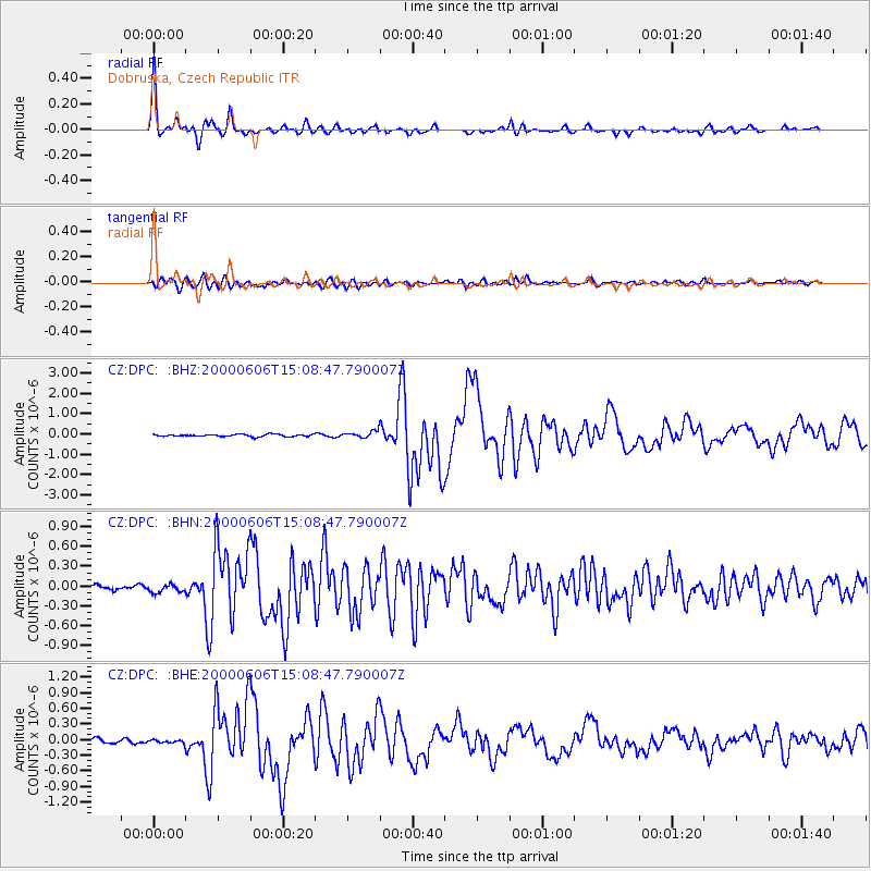
Earthquake location: Southeast Of Ryukyu Islands
Earthquake latitude/longitude: 29.4/131.4
Earthquake time(UTC): 2000/06/06 (158) 14:57:02 GMT
Earthquake Depth: 33 km
Earthquake Magnitude: 5.8 MB, 6.0 MS, 6.4 MW, 6.4 MW
Earthquake Catalog/Contributor: WHDF/NEIC
Network: CZ Czech Regional Seismic Network
Station: DPC Dobruska, Czech Republic
Lat/Lon: 50.36 N/16.41 E
Elevation: 760 m
Distance: 82.0 deg
Az: 324.115 deg
Baz: 52.975 deg
Ray Param: 0.047143806
Estimated Moho Depth: 26.75 km
Estimated Crust Vp/Vs: 1.84
Assumed Crust Vp: 6.194 km/s
Estimated Crust Vs: 3.376 km/s
Estimated Crust Poisson's Ratio: 0.29
Radial Match: 97.09248 %
Radial Bump: 286
Transverse Match: 87.32262 %
Transverse Bump: 400
SOD ConfigId: 3744
Insert Time: 2010-02-27 01:17:07.259 +0000
GWidth: 2.5
Max Bumps: 400
Tol: 0.001

Signal To Noise

ChannelStoNSTALTA
CZ:DPC: :BHN:20000606T15:08:47.790007Z1.04780386.047419E-85.7715187E-8
CZ:DPC: :BHE:20000606T15:08:47.790007Z0.64782263.1117743E-84.803436E-8
CZ:DPC: :BHZ:20000606T15:08:47.790007Z2.9150811.6107363E-75.5255285E-8
Arrivals
Ps3.7 SECOND
PpPs12 SECOND
PsPs/PpSs16 SECOND