You are here: Home > Network List > CI - Caltech Regional Seismic Network Stations List
> Station GSC Goldstone, Goldstone Lake, CA, USA > Earthquake Result Viewer
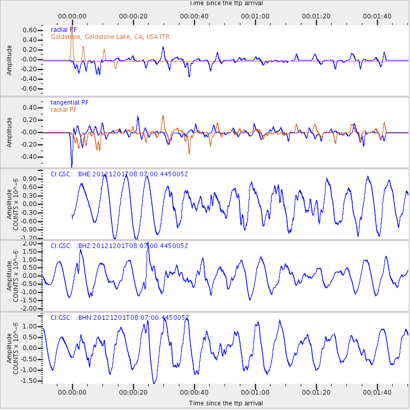
GSC Goldstone, Goldstone Lake, CA, USA - Earthquake Result Viewer
*The percent match for this event was below the threshold and hence no stack was calculated.
| Earthquake location: |
Alaska Peninsula |
| Earthquake latitude/longitude: |
58.4/-154.1 |
| Earthquake time(UTC): |
2012/12/01 (336) 08:00:57 GMT |
| Earthquake Depth: |
92 km |
| Earthquake Magnitude: |
5.5 MB, 5.3 MW, 5.4 MW |
| Earthquake Catalog/Contributor: |
WHDF/NEIC |
|
| Network: |
CI Caltech Regional Seismic Network |
| Station: |
GSC Goldstone, Goldstone Lake, CA, USA |
| Lat/Lon: |
35.30 N/116.81 W |
| Elevation: |
1000 m |
|
| Distance: |
33.7 deg |
| Az: |
116.798 deg |
| Baz: |
324.953 deg |
| Ray Param: |
$rayparam |
*The percent match for this event was below the threshold and hence was not used in the summary stack. |
|
| Radial Match: |
69.939835 % |
| Radial Bump: |
400 |
| Transverse Match: |
52.69361 % |
| Transverse Bump: |
400 |
| SOD ConfigId: |
486959 |
| Insert Time: |
2013-03-23 05:50:09.916 +0000 |
| GWidth: |
2.5 |
| Max Bumps: |
400 |
| Tol: |
0.001 |
|
Signal To Noise
| Channel | StoN | STA | LTA |
| CI:GSC: :BHZ:20121201T08:07:00.445005Z | 1.8983022 | 8.9464106E-7 | 4.7128486E-7 |
| CI:GSC: :BHN:20121201T08:07:00.445005Z | 0.6671331 | 3.0342784E-7 | 4.5482355E-7 |
| CI:GSC: :BHE:20121201T08:07:00.445005Z | 0.6733307 | 4.6148344E-7 | 6.8537406E-7 |
| Arrivals |
| Ps | |
| PpPs | |
| PsPs/PpSs | |


