You are here: Home > Network List > CI - Caltech Regional Seismic Network Stations List
> Station SLA SLA, Trona, CA, USA > Earthquake Result Viewer
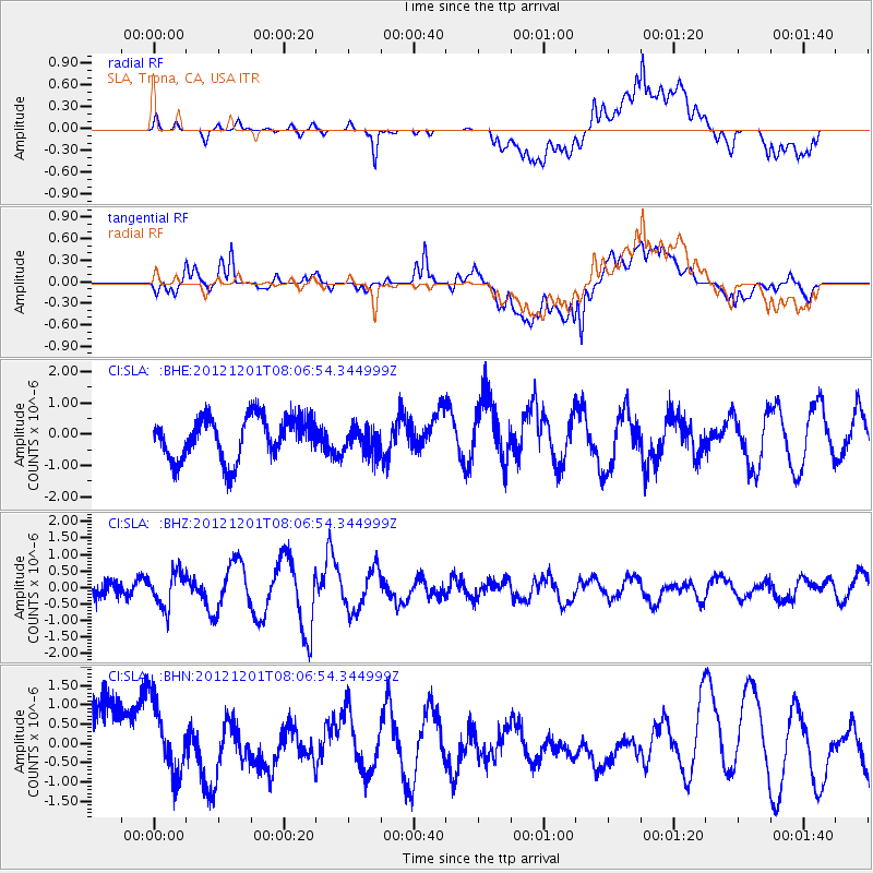
SLA SLA, Trona, CA, USA - Earthquake Result Viewer
*The percent match for this event was below the threshold and hence no stack was calculated.
| Earthquake location: |
Alaska Peninsula |
| Earthquake latitude/longitude: |
58.4/-154.1 |
| Earthquake time(UTC): |
2012/12/01 (336) 08:00:57 GMT |
| Earthquake Depth: |
92 km |
| Earthquake Magnitude: |
5.5 MB, 5.3 MW, 5.4 MW |
| Earthquake Catalog/Contributor: |
WHDF/NEIC |
|
| Network: |
CI Caltech Regional Seismic Network |
| Station: |
SLA SLA, Trona, CA, USA |
| Lat/Lon: |
35.89 N/117.28 W |
| Elevation: |
1174 m |
|
| Distance: |
33.0 deg |
| Az: |
116.76 deg |
| Baz: |
324.645 deg |
| Ray Param: |
$rayparam |
*The percent match for this event was below the threshold and hence was not used in the summary stack. |
|
| Radial Match: |
68.05804 % |
| Radial Bump: |
400 |
| Transverse Match: |
62.601448 % |
| Transverse Bump: |
400 |
| SOD ConfigId: |
486959 |
| Insert Time: |
2013-03-23 05:50:45.745 +0000 |
| GWidth: |
2.5 |
| Max Bumps: |
400 |
| Tol: |
0.001 |
|
Signal To Noise
| Channel | StoN | STA | LTA |
| CI:SLA: :BHZ:20121201T08:06:54.344999Z | 2.3651893 | 5.323435E-7 | 2.2507437E-7 |
| CI:SLA: :BHN:20121201T08:06:54.344999Z | 0.9479256 | 1.0677792E-6 | 1.1264376E-6 |
| CI:SLA: :BHE:20121201T08:06:54.344999Z | 0.6072528 | 4.098321E-7 | 6.748954E-7 |
| Arrivals |
| Ps | |
| PpPs | |
| PsPs/PpSs | |


