You are here: Home > Network List > TA - USArray Transportable Network (new EarthScope stations) Stations List
> Station Y43A Makayla and Karen, Gunnison, MS, USA > Earthquake Result Viewer
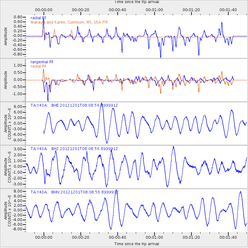
Y43A Makayla and Karen, Gunnison, MS, USA - Earthquake Result Viewer
*The percent match for this event was below the threshold and hence no stack was calculated.
| Earthquake location: |
Alaska Peninsula |
| Earthquake latitude/longitude: |
58.4/-154.1 |
| Earthquake time(UTC): |
2012/12/01 (336) 08:00:57 GMT |
| Earthquake Depth: |
92 km |
| Earthquake Magnitude: |
5.5 MB, 5.3 MW, 5.4 MW |
| Earthquake Catalog/Contributor: |
WHDF/NEIC |
|
| Network: |
TA USArray Transportable Network (new EarthScope stations) |
| Station: |
Y43A Makayla and Karen, Gunnison, MS, USA |
| Lat/Lon: |
33.91 N/90.93 W |
| Elevation: |
46 m |
|
| Distance: |
48.0 deg |
| Az: |
92.06 deg |
| Baz: |
320.777 deg |
| Ray Param: |
$rayparam |
*The percent match for this event was below the threshold and hence was not used in the summary stack. |
|
| Radial Match: |
63.148476 % |
| Radial Bump: |
306 |
| Transverse Match: |
42.122223 % |
| Transverse Bump: |
247 |
| SOD ConfigId: |
486959 |
| Insert Time: |
2013-03-23 05:57:45.680 +0000 |
| GWidth: |
2.5 |
| Max Bumps: |
400 |
| Tol: |
0.001 |
|
Signal To Noise
| Channel | StoN | STA | LTA |
| TA:Y43A: :BHZ:20121201T08:08:56.899991Z | 1.4909512 | 1.3694824E-6 | 9.1852934E-7 |
| TA:Y43A: :BHN:20121201T08:08:56.899991Z | 0.899736 | 2.5338695E-6 | 2.8162367E-6 |
| TA:Y43A: :BHE:20121201T08:08:56.899991Z | 2.8655343 | 7.4935356E-6 | 2.6150572E-6 |
| Arrivals |
| Ps | |
| PpPs | |
| PsPs/PpSs | |


