You are here: Home > Network List > TA - USArray Transportable Network (new EarthScope stations) Stations List
> Station Q42A Golden Eagle, IL, USA > Earthquake Result Viewer
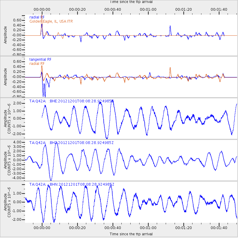
Q42A Golden Eagle, IL, USA - Earthquake Result Viewer
*The percent match for this event was below the threshold and hence no stack was calculated.
| Earthquake location: |
Alaska Peninsula |
| Earthquake latitude/longitude: |
58.4/-154.1 |
| Earthquake time(UTC): |
2012/12/01 (336) 08:00:57 GMT |
| Earthquake Depth: |
92 km |
| Earthquake Magnitude: |
5.5 MB, 5.3 MW, 5.4 MW |
| Earthquake Catalog/Contributor: |
WHDF/NEIC |
|
| Network: |
TA USArray Transportable Network (new EarthScope stations) |
| Station: |
Q42A Golden Eagle, IL, USA |
| Lat/Lon: |
38.91 N/90.53 W |
| Elevation: |
175 m |
|
| Distance: |
44.4 deg |
| Az: |
87.208 deg |
| Baz: |
317.648 deg |
| Ray Param: |
$rayparam |
*The percent match for this event was below the threshold and hence was not used in the summary stack. |
|
| Radial Match: |
59.92223 % |
| Radial Bump: |
400 |
| Transverse Match: |
92.39569 % |
| Transverse Bump: |
400 |
| SOD ConfigId: |
486959 |
| Insert Time: |
2013-03-23 05:57:59.823 +0000 |
| GWidth: |
2.5 |
| Max Bumps: |
400 |
| Tol: |
0.001 |
|
Signal To Noise
| Channel | StoN | STA | LTA |
| TA:Q42A: :BHZ:20121201T08:08:28.924985Z | 2.7031546 | 2.3853543E-6 | 8.8243354E-7 |
| TA:Q42A: :BHN:20121201T08:08:28.924985Z | 1.941967 | 1.4365911E-6 | 7.3976076E-7 |
| TA:Q42A: :BHE:20121201T08:08:28.924985Z | 1.5515504 | 1.5264939E-6 | 9.838507E-7 |
| Arrivals |
| Ps | |
| PpPs | |
| PsPs/PpSs | |


