You are here: Home > Network List > TA - USArray Transportable Network (new EarthScope stations) Stations List
> Station E41A Kenton, MI, USA > Earthquake Result Viewer
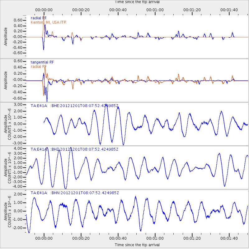
E41A Kenton, MI, USA - Earthquake Result Viewer
*The percent match for this event was below the threshold and hence no stack was calculated.
| Earthquake location: |
Alaska Peninsula |
| Earthquake latitude/longitude: |
58.4/-154.1 |
| Earthquake time(UTC): |
2012/12/01 (336) 08:00:57 GMT |
| Earthquake Depth: |
92 km |
| Earthquake Magnitude: |
5.5 MB, 5.3 MW, 5.4 MW |
| Earthquake Catalog/Contributor: |
WHDF/NEIC |
|
| Network: |
TA USArray Transportable Network (new EarthScope stations) |
| Station: |
E41A Kenton, MI, USA |
| Lat/Lon: |
46.46 N/88.96 W |
| Elevation: |
377 m |
|
| Distance: |
39.9 deg |
| Az: |
78.002 deg |
| Baz: |
311.872 deg |
| Ray Param: |
$rayparam |
*The percent match for this event was below the threshold and hence was not used in the summary stack. |
|
| Radial Match: |
70.64463 % |
| Radial Bump: |
400 |
| Transverse Match: |
91.76109 % |
| Transverse Bump: |
303 |
| SOD ConfigId: |
486959 |
| Insert Time: |
2013-03-23 05:59:11.176 +0000 |
| GWidth: |
2.5 |
| Max Bumps: |
400 |
| Tol: |
0.001 |
|
Signal To Noise
| Channel | StoN | STA | LTA |
| TA:E41A: :BHZ:20121201T08:07:52.424985Z | 4.651351 | 3.0174344E-6 | 6.487222E-7 |
| TA:E41A: :BHN:20121201T08:07:52.424985Z | 0.6632636 | 7.9225913E-7 | 1.1944861E-6 |
| TA:E41A: :BHE:20121201T08:07:52.424985Z | 2.5778337 | 2.180088E-6 | 8.457054E-7 |
| Arrivals |
| Ps | |
| PpPs | |
| PsPs/PpSs | |


