You are here: Home > Network List > TA - USArray Transportable Network (new EarthScope stations) Stations List
> Station 349A Repton, AL, USA > Earthquake Result Viewer
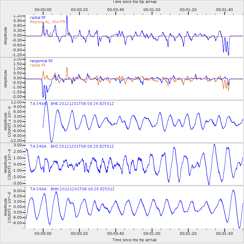
349A Repton, AL, USA - Earthquake Result Viewer
*The percent match for this event was below the threshold and hence no stack was calculated.
| Earthquake location: |
Alaska Peninsula |
| Earthquake latitude/longitude: |
58.4/-154.1 |
| Earthquake time(UTC): |
2012/12/01 (336) 08:00:57 GMT |
| Earthquake Depth: |
92 km |
| Earthquake Magnitude: |
5.5 MB, 5.3 MW, 5.4 MW |
| Earthquake Catalog/Contributor: |
WHDF/NEIC |
|
| Network: |
TA USArray Transportable Network (new EarthScope stations) |
| Station: |
349A Repton, AL, USA |
| Lat/Lon: |
31.35 N/87.19 W |
| Elevation: |
88 m |
|
| Distance: |
51.9 deg |
| Az: |
90.922 deg |
| Baz: |
322.05 deg |
| Ray Param: |
$rayparam |
*The percent match for this event was below the threshold and hence was not used in the summary stack. |
|
| Radial Match: |
72.964455 % |
| Radial Bump: |
400 |
| Transverse Match: |
72.75573 % |
| Transverse Bump: |
352 |
| SOD ConfigId: |
486959 |
| Insert Time: |
2013-03-23 06:00:07.803 +0000 |
| GWidth: |
2.5 |
| Max Bumps: |
400 |
| Tol: |
0.001 |
|
Signal To Noise
| Channel | StoN | STA | LTA |
| TA:349A: :BHZ:20121201T08:09:26.82501Z | 0.34912175 | 7.07109E-7 | 2.0253938E-6 |
| TA:349A: :BHN:20121201T08:09:26.82501Z | 2.6405153 | 6.3661914E-6 | 2.4109656E-6 |
| TA:349A: :BHE:20121201T08:09:26.82501Z | 0.40048286 | 2.2760714E-6 | 5.683318E-6 |
| Arrivals |
| Ps | |
| PpPs | |
| PsPs/PpSs | |


