You are here: Home > Network List > AU - Australian Seismological Centre Stations List
> Station MEEK Meekatharra, Western Australia > Earthquake Result Viewer
MEEK Meekatharra, Western Australia - Earthquake Result Viewer
| Earthquake location: |
Vanuatu Islands |
| Earthquake latitude/longitude: |
-17.0/167.6 |
| Earthquake time(UTC): |
2012/12/02 (337) 00:54:22 GMT |
| Earthquake Depth: |
32 km |
| Earthquake Magnitude: |
6.1 MB, 6.0 MS, 6.1 MW, 6.2 MW |
| Earthquake Catalog/Contributor: |
WHDF/NEIC |
|
| Network: |
AU Australian Seismological Centre |
| Station: |
MEEK Meekatharra, Western Australia |
| Lat/Lon: |
26.64 S/118.61 E |
| Elevation: |
529 m |
|
| Distance: |
46.3 deg |
| Az: |
249.218 deg |
| Baz: |
88.408 deg |
| Ray Param: |
0.07067498 |
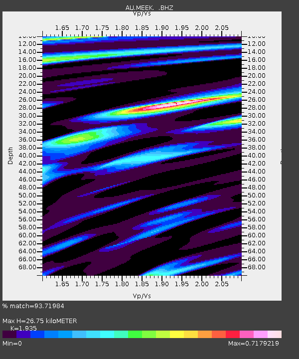
| Estimated Moho Depth: |
26.75 km |
| Estimated Crust Vp/Vs: |
1.93 |
| Assumed Crust Vp: |
6.459 km/s |
| Estimated Crust Vs: |
3.338 km/s |
| Estimated Crust Poisson's Ratio: |
0.32 |
|
| Radial Match: |
93.71984 % |
| Radial Bump: |
325 |
| Transverse Match: |
71.51397 % |
| Transverse Bump: |
400 |
| SOD ConfigId: |
488671 |
| Insert Time: |
2013-03-29 03:09:18.442 +0000 |
| GWidth: |
2.5 |
| Max Bumps: |
400 |
| Tol: |
0.001 |
|

Signal To Noise
| Channel | StoN | STA | LTA |
| AU:MEEK: :BHZ:20121202T01:02:14.695005Z | 4.8430777 | 1.1374665E-6 | 2.3486439E-7 |
| AU:MEEK: :BHN:20121202T01:02:14.695005Z | 1.6075146 | 3.4002605E-7 | 2.1152283E-7 |
| AU:MEEK: :BHE:20121202T01:02:14.695005Z | 3.2011871 | 6.655297E-7 | 2.0790091E-7 |
| Arrivals |
| Ps | 4.1 SECOND |
| PpPs | 11 SECOND |
| PsPs/PpSs | 16 SECOND |


