You are here: Home > Network List > AU - Australian Seismological Centre Stations List
> Station KDU Kakadu, NT > Earthquake Result Viewer
KDU Kakadu, NT - Earthquake Result Viewer
| Earthquake location: |
Vanuatu Islands |
| Earthquake latitude/longitude: |
-17.0/167.6 |
| Earthquake time(UTC): |
2012/12/02 (337) 00:54:22 GMT |
| Earthquake Depth: |
32 km |
| Earthquake Magnitude: |
6.1 MB, 6.0 MS, 6.1 MW, 6.2 MW |
| Earthquake Catalog/Contributor: |
WHDF/NEIC |
|
| Network: |
AU Australian Seismological Centre |
| Station: |
KDU Kakadu, NT |
| Lat/Lon: |
12.69 S/132.47 E |
| Elevation: |
46 m |
|
| Distance: |
34.2 deg |
| Az: |
272.306 deg |
| Baz: |
101.531 deg |
| Ray Param: |
0.07778923 |
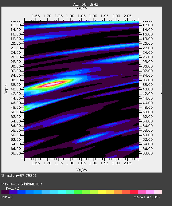
| Estimated Moho Depth: |
37.5 km |
| Estimated Crust Vp/Vs: |
1.72 |
| Assumed Crust Vp: |
6.61 km/s |
| Estimated Crust Vs: |
3.843 km/s |
| Estimated Crust Poisson's Ratio: |
0.24 |
|
| Radial Match: |
87.79891 % |
| Radial Bump: |
366 |
| Transverse Match: |
66.393936 % |
| Transverse Bump: |
400 |
| SOD ConfigId: |
488671 |
| Insert Time: |
2013-03-29 03:09:30.502 +0000 |
| GWidth: |
2.5 |
| Max Bumps: |
400 |
| Tol: |
0.001 |
|

Signal To Noise
| Channel | StoN | STA | LTA |
| AU:KDU: :BHZ:20121202T01:00:35.144987Z | 3.693313 | 7.1332204E-7 | 1.931388E-7 |
| AU:KDU: :BHN:20121202T01:00:35.144987Z | 0.7500271 | 1.4641117E-7 | 1.9520783E-7 |
| AU:KDU: :BHE:20121202T01:00:35.144987Z | 1.939121 | 3.3568327E-7 | 1.7311105E-7 |
| Arrivals |
| Ps | 4.4 SECOND |
| PpPs | 14 SECOND |
| PsPs/PpSs | 19 SECOND |


