You are here: Home > Network List > UW - Pacific Northwest Regional Seismic Network Stations List
> Station RATT Rattlesnake Lake, WA > Earthquake Result Viewer
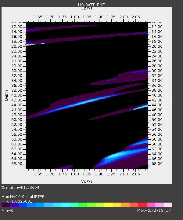
RATT Rattlesnake Lake, WA - Earthquake Result Viewer
| Earthquake location: |
Kermadec Islands, New Zealand |
| Earthquake latitude/longitude: |
-30.2/-177.2 |
| Earthquake time(UTC): |
2014/06/23 (174) 20:59:14 GMT |
| Earthquake Depth: |
24 km |
| Earthquake Magnitude: |
5.1 mb |
| Earthquake Catalog/Contributor: |
ISC/ISC |
|
| Network: |
UW Pacific Northwest Regional Seismic Network |
| Station: |
RATT Rattlesnake Lake, WA |
| Lat/Lon: |
47.43 N/121.80 W |
| Elevation: |
440 m |
|
| Distance: |
92.0 deg |
| Az: |
34.015 deg |
| Baz: |
225.475 deg |
| Ray Param: |
0.041523483 |
| Estimated Moho Depth: |
19.0 km |
| Estimated Crust Vp/Vs: |
1.60 |
| Assumed Crust Vp: |
6.597 km/s |
| Estimated Crust Vs: |
4.117 km/s |
| Estimated Crust Poisson's Ratio: |
0.18 |
|
| Radial Match: |
91.13604 % |
| Radial Bump: |
400 |
| Transverse Match: |
95.763374 % |
| Transverse Bump: |
298 |
| SOD ConfigId: |
3390531 |
| Insert Time: |
2019-04-12 10:37:52.550 +0000 |
| GWidth: |
2.5 |
| Max Bumps: |
400 |
| Tol: |
0.001 |
|

Signal To Noise
| Channel | StoN | STA | LTA |
| UW:RATT: :BHZ:20140623T21:11:49.414973Z | 0.890792 | 1.3754272E-4 | 1.5440497E-4 |
| UW:RATT: :BHN:20140623T21:11:49.414973Z | 0.5341658 | 2.2325294E-5 | 4.179469E-5 |
| UW:RATT: :BHE:20140623T21:11:49.414973Z | 2.3898683 | 3.0222625E-4 | 1.2646147E-4 |
| Arrivals |
| Ps | 1.8 SECOND |
| PpPs | 7.3 SECOND |
| PsPs/PpSs | 9.1 SECOND |


