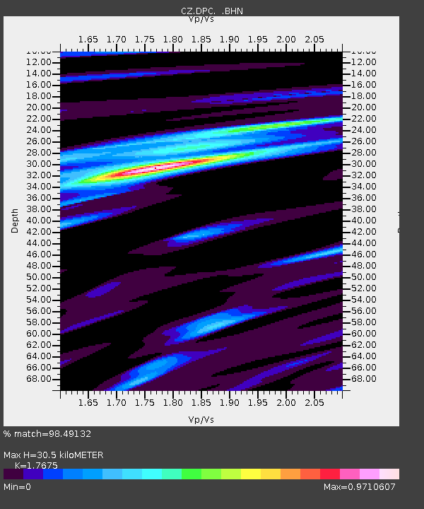
DPC Dobruska, Czech Republic - Earthquake Result Viewer
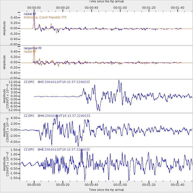
Earthquake location: Kodiak Island Region, Alaska
Earthquake latitude/longitude: 57.1/-153.2
Earthquake time(UTC): 2001/01/10 (010) 16:02:44 GMT
Earthquake Depth: 33 km
Earthquake Magnitude: 6.2 MB, 6.8 MS, 7.1 MW, 6.8 ML
Earthquake Catalog/Contributor: WHDF/NEIC
Network: CZ Czech Regional Seismic Network
Station: DPC Dobruska, Czech Republic
Lat/Lon: 50.36 N/16.41 E
Elevation: 760 m
Distance: 72.6 deg
Az: 6.946 deg
Baz: 354.083 deg
Ray Param: 0.053515356
Estimated Moho Depth: 30.5 km
Estimated Crust Vp/Vs: 1.77
Assumed Crust Vp: 6.194 km/s
Estimated Crust Vs: 3.504 km/s
Estimated Crust Poisson's Ratio: 0.26
Radial Match: 98.49132 %
Radial Bump: 264
Transverse Match: 91.97822 %
Transverse Bump: 400
SOD ConfigId: 3744
Insert Time: 2010-02-27 01:17:44.445 +0000
GWidth: 2.5
Max Bumps: 400
Tol: 0.001

Signal To Noise

ChannelStoNSTALTA
CZ:DPC: :BHN:20010110T16:13:37.229023Z11.0658061.1401617E-61.03034665E-7
CZ:DPC: :BHE:20010110T16:13:37.229023Z1.53671611.4982184E-79.749481E-8
CZ:DPC: :BHZ:20010110T16:13:37.229023Z24.3421042.4413694E-61.00294095E-7
Arrivals
Ps3.9 SECOND
PpPs13 SECOND
PsPs/PpSs17 SECOND