You are here: Home > Network List > TA - USArray Transportable Network (new EarthScope stations) Stations List
> Station TPFO Pinon Flats, CA, USA > Earthquake Result Viewer
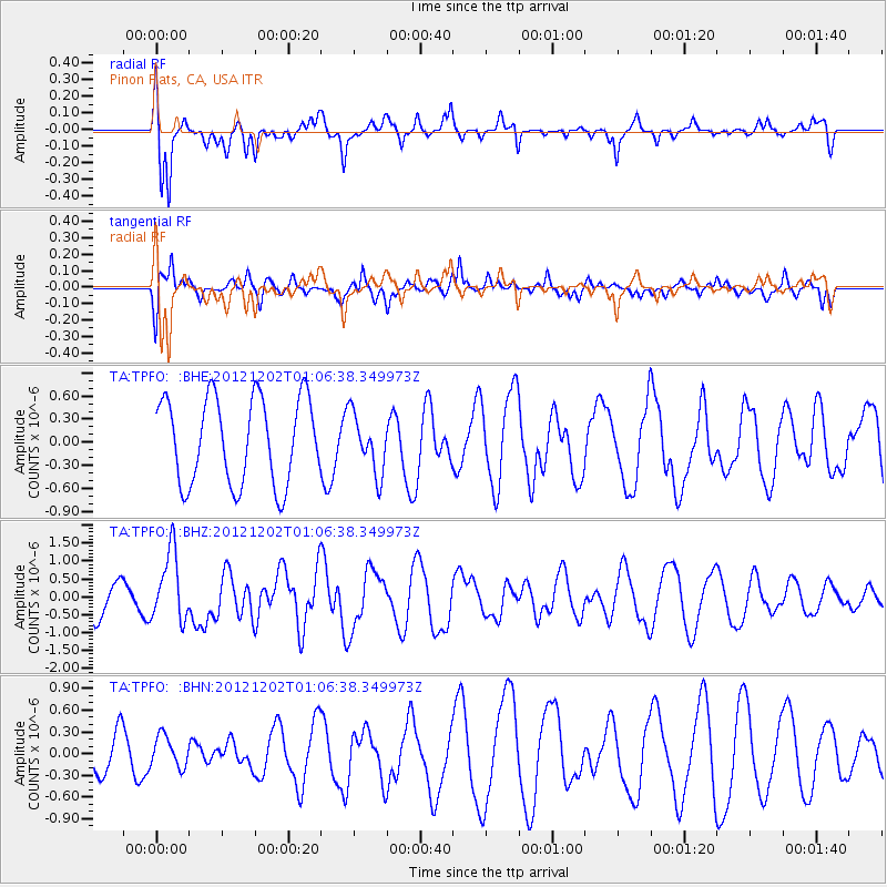
TPFO Pinon Flats, CA, USA - Earthquake Result Viewer
*The percent match for this event was below the threshold and hence no stack was calculated.
| Earthquake location: |
Vanuatu Islands |
| Earthquake latitude/longitude: |
-17.0/167.6 |
| Earthquake time(UTC): |
2012/12/02 (337) 00:54:22 GMT |
| Earthquake Depth: |
32 km |
| Earthquake Magnitude: |
6.1 MB, 6.0 MS, 6.1 MW, 6.2 MW |
| Earthquake Catalog/Contributor: |
WHDF/NEIC |
|
| Network: |
TA USArray Transportable Network (new EarthScope stations) |
| Station: |
TPFO Pinon Flats, CA, USA |
| Lat/Lon: |
33.61 N/116.45 W |
| Elevation: |
1275 m |
|
| Distance: |
88.0 deg |
| Az: |
54.088 deg |
| Baz: |
248.234 deg |
| Ray Param: |
$rayparam |
*The percent match for this event was below the threshold and hence was not used in the summary stack. |
|
| Radial Match: |
76.640915 % |
| Radial Bump: |
372 |
| Transverse Match: |
48.315285 % |
| Transverse Bump: |
400 |
| SOD ConfigId: |
488671 |
| Insert Time: |
2013-03-29 03:15:29.644 +0000 |
| GWidth: |
2.5 |
| Max Bumps: |
400 |
| Tol: |
0.001 |
|
Signal To Noise
| Channel | StoN | STA | LTA |
| TA:TPFO: :BHZ:20121202T01:06:38.349973Z | 1.8207401 | 9.579217E-7 | 5.261166E-7 |
| TA:TPFO: :BHN:20121202T01:06:38.349973Z | 0.6102916 | 2.1477452E-7 | 3.5192113E-7 |
| TA:TPFO: :BHE:20121202T01:06:38.349973Z | 0.6825839 | 3.816295E-7 | 5.590953E-7 |
| Arrivals |
| Ps | |
| PpPs | |
| PsPs/PpSs | |


