You are here: Home > Network List > UW - Pacific Northwest Regional Seismic Network Stations List
> Station UMAT Pilot Rock, OR, USA > Earthquake Result Viewer
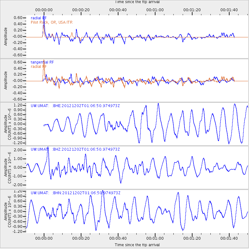
UMAT Pilot Rock, OR, USA - Earthquake Result Viewer
*The percent match for this event was below the threshold and hence no stack was calculated.
| Earthquake location: |
Vanuatu Islands |
| Earthquake latitude/longitude: |
-17.0/167.6 |
| Earthquake time(UTC): |
2012/12/02 (337) 00:54:22 GMT |
| Earthquake Depth: |
32 km |
| Earthquake Magnitude: |
6.1 MB, 6.0 MS, 6.1 MW, 6.2 MW |
| Earthquake Catalog/Contributor: |
WHDF/NEIC |
|
| Network: |
UW Pacific Northwest Regional Seismic Network |
| Station: |
UMAT Pilot Rock, OR, USA |
| Lat/Lon: |
45.29 N/118.96 W |
| Elevation: |
1318 m |
|
| Distance: |
90.7 deg |
| Az: |
42.572 deg |
| Baz: |
246.512 deg |
| Ray Param: |
$rayparam |
*The percent match for this event was below the threshold and hence was not used in the summary stack. |
|
| Radial Match: |
45.072662 % |
| Radial Bump: |
400 |
| Transverse Match: |
40.85035 % |
| Transverse Bump: |
358 |
| SOD ConfigId: |
488671 |
| Insert Time: |
2013-03-29 03:16:35.917 +0000 |
| GWidth: |
2.5 |
| Max Bumps: |
400 |
| Tol: |
0.001 |
|
Signal To Noise
| Channel | StoN | STA | LTA |
| UW:UMAT: :BHZ:20121202T01:06:50.974973Z | 2.4419146 | 1.0050834E-6 | 4.1159646E-7 |
| UW:UMAT: :BHN:20121202T01:06:50.974973Z | 0.6234235 | 2.3565609E-7 | 3.780032E-7 |
| UW:UMAT: :BHE:20121202T01:06:50.974973Z | 1.1532528 | 4.3704165E-7 | 3.789643E-7 |
| Arrivals |
| Ps | |
| PpPs | |
| PsPs/PpSs | |


