You are here: Home > Network List > CI - Caltech Regional Seismic Network Stations List
> Station TIN Tinemaha, Big Pine, CA, USA > Earthquake Result Viewer
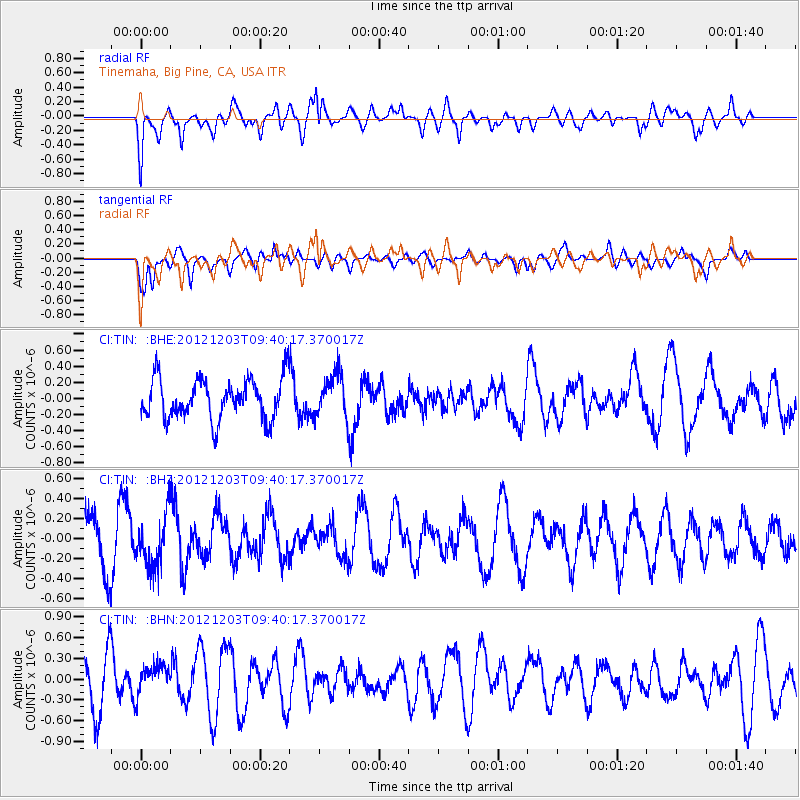
TIN Tinemaha, Big Pine, CA, USA - Earthquake Result Viewer
*The percent match for this event was below the threshold and hence no stack was calculated.
| Earthquake location: |
Pacific-Antarctic Ridge |
| Earthquake latitude/longitude: |
-54.7/-136.2 |
| Earthquake time(UTC): |
2012/12/03 (338) 09:27:37 GMT |
| Earthquake Depth: |
10 km |
| Earthquake Magnitude: |
5.6 MW, 5.4 MS, 5.1 MB |
| Earthquake Catalog/Contributor: |
WHDF/NEIC |
|
| Network: |
CI Caltech Regional Seismic Network |
| Station: |
TIN Tinemaha, Big Pine, CA, USA |
| Lat/Lon: |
37.05 N/118.23 W |
| Elevation: |
1197 m |
|
| Distance: |
92.7 deg |
| Az: |
14.34 deg |
| Baz: |
190.359 deg |
| Ray Param: |
$rayparam |
*The percent match for this event was below the threshold and hence was not used in the summary stack. |
|
| Radial Match: |
57.47602 % |
| Radial Bump: |
400 |
| Transverse Match: |
55.555145 % |
| Transverse Bump: |
400 |
| SOD ConfigId: |
488671 |
| Insert Time: |
2013-03-29 03:18:38.753 +0000 |
| GWidth: |
2.5 |
| Max Bumps: |
400 |
| Tol: |
0.001 |
|
Signal To Noise
| Channel | StoN | STA | LTA |
| CI:TIN: :BHZ:20121203T09:40:17.370017Z | 1.2947521 | 2.587112E-7 | 1.9981523E-7 |
| CI:TIN: :BHN:20121203T09:40:17.370017Z | 0.6945975 | 2.1823004E-7 | 3.1418202E-7 |
| CI:TIN: :BHE:20121203T09:40:17.370017Z | 1.0594267 | 2.6626316E-7 | 2.513276E-7 |
| Arrivals |
| Ps | |
| PpPs | |
| PsPs/PpSs | |


