You are here: Home > Network List > CI - Caltech Regional Seismic Network Stations List
> Station FUR Furnace Creek, CA, USA > Earthquake Result Viewer
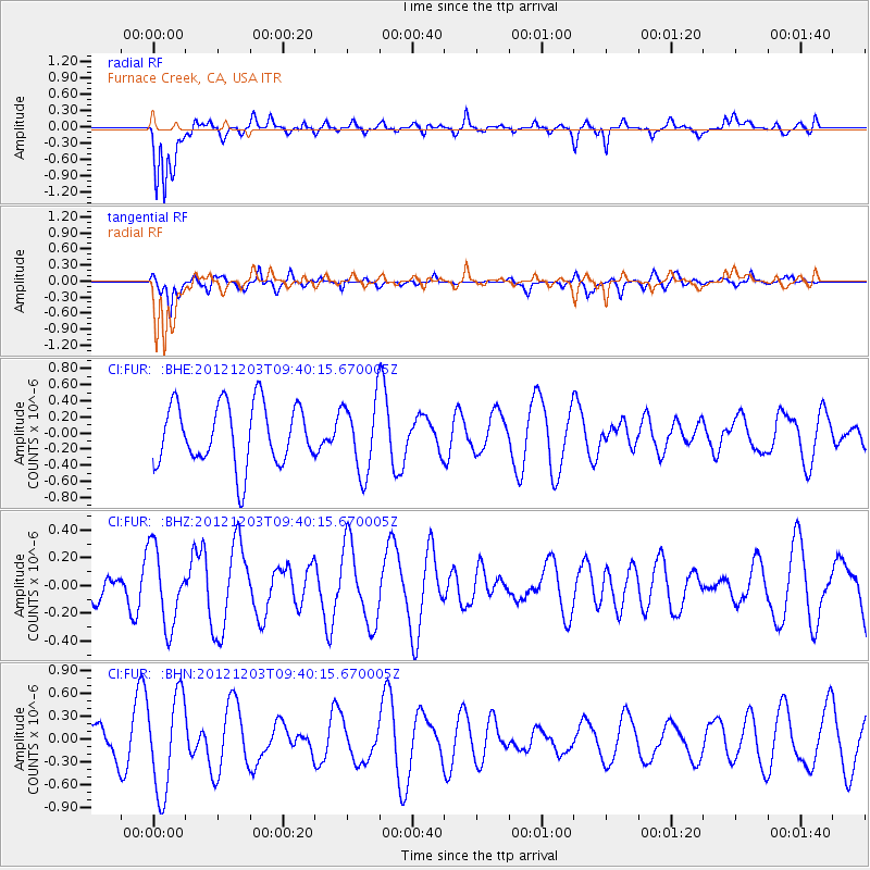
FUR Furnace Creek, CA, USA - Earthquake Result Viewer
*The percent match for this event was below the threshold and hence no stack was calculated.
| Earthquake location: |
Pacific-Antarctic Ridge |
| Earthquake latitude/longitude: |
-54.7/-136.2 |
| Earthquake time(UTC): |
2012/12/03 (338) 09:27:37 GMT |
| Earthquake Depth: |
10 km |
| Earthquake Magnitude: |
5.6 MW, 5.4 MS, 5.1 MB |
| Earthquake Catalog/Contributor: |
WHDF/NEIC |
|
| Network: |
CI Caltech Regional Seismic Network |
| Station: |
FUR Furnace Creek, CA, USA |
| Lat/Lon: |
36.47 N/116.86 W |
| Elevation: |
-37.0 m |
|
| Distance: |
92.3 deg |
| Az: |
15.528 deg |
| Baz: |
191.122 deg |
| Ray Param: |
$rayparam |
*The percent match for this event was below the threshold and hence was not used in the summary stack. |
|
| Radial Match: |
71.90475 % |
| Radial Bump: |
400 |
| Transverse Match: |
42.175663 % |
| Transverse Bump: |
310 |
| SOD ConfigId: |
488671 |
| Insert Time: |
2013-03-29 03:18:47.696 +0000 |
| GWidth: |
2.5 |
| Max Bumps: |
400 |
| Tol: |
0.001 |
|
Signal To Noise
| Channel | StoN | STA | LTA |
| CI:FUR: :BHZ:20121203T09:40:15.670005Z | 1.8187187 | 2.7648133E-7 | 1.5201984E-7 |
| CI:FUR: :BHN:20121203T09:40:15.670005Z | 4.150794 | 6.3853565E-7 | 1.5383458E-7 |
| CI:FUR: :BHE:20121203T09:40:15.670005Z | 1.1861805 | 4.4820484E-7 | 3.778555E-7 |
| Arrivals |
| Ps | |
| PpPs | |
| PsPs/PpSs | |


