You are here: Home > Network List > TA - USArray Transportable Network (new EarthScope stations) Stations List
> Station 121A Cookes Peak, Deming, NM, USA > Earthquake Result Viewer
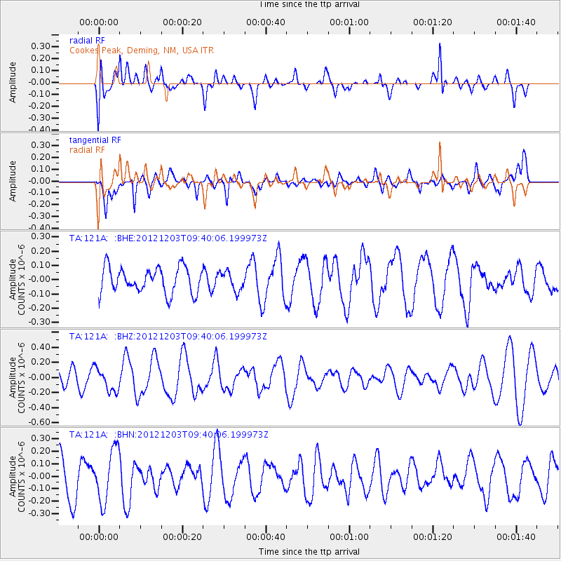
121A Cookes Peak, Deming, NM, USA - Earthquake Result Viewer
*The percent match for this event was below the threshold and hence no stack was calculated.
| Earthquake location: |
Pacific-Antarctic Ridge |
| Earthquake latitude/longitude: |
-54.7/-136.2 |
| Earthquake time(UTC): |
2012/12/03 (338) 09:27:37 GMT |
| Earthquake Depth: |
10 km |
| Earthquake Magnitude: |
5.6 MW, 5.4 MS, 5.1 MB |
| Earthquake Catalog/Contributor: |
WHDF/NEIC |
|
| Network: |
TA USArray Transportable Network (new EarthScope stations) |
| Station: |
121A Cookes Peak, Deming, NM, USA |
| Lat/Lon: |
32.53 N/107.79 W |
| Elevation: |
1652 m |
|
| Distance: |
90.2 deg |
| Az: |
23.737 deg |
| Baz: |
196.069 deg |
| Ray Param: |
$rayparam |
*The percent match for this event was below the threshold and hence was not used in the summary stack. |
|
| Radial Match: |
50.700253 % |
| Radial Bump: |
400 |
| Transverse Match: |
62.761154 % |
| Transverse Bump: |
400 |
| SOD ConfigId: |
488671 |
| Insert Time: |
2013-03-29 03:20:16.850 +0000 |
| GWidth: |
2.5 |
| Max Bumps: |
400 |
| Tol: |
0.001 |
|
Signal To Noise
| Channel | StoN | STA | LTA |
| TA:121A: :BHZ:20121203T09:40:06.199973Z | 1.2997283 | 1.5094113E-7 | 1.16132846E-7 |
| TA:121A: :BHN:20121203T09:40:06.199973Z | 1.7428248 | 2.1450909E-7 | 1.2308126E-7 |
| TA:121A: :BHE:20121203T09:40:06.199973Z | 0.7546714 | 6.7460086E-8 | 8.9390014E-8 |
| Arrivals |
| Ps | |
| PpPs | |
| PsPs/PpSs | |


