You are here: Home > Network List > CI - Caltech Regional Seismic Network Stations List
> Station FUR Furnace Creek, CA, USA > Earthquake Result Viewer
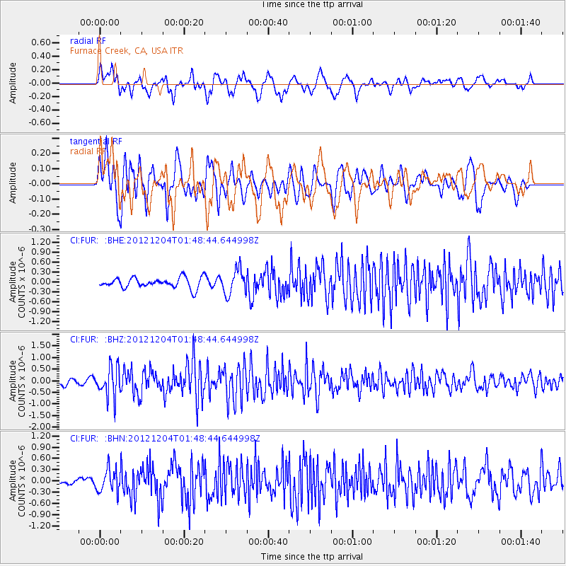
FUR Furnace Creek, CA, USA - Earthquake Result Viewer
*The percent match for this event was below the threshold and hence no stack was calculated.
| Earthquake location: |
Southern Alaska |
| Earthquake latitude/longitude: |
61.2/-150.8 |
| Earthquake time(UTC): |
2012/12/04 (339) 01:42:48 GMT |
| Earthquake Depth: |
62 km |
| Earthquake Magnitude: |
5.6 MB, 5.8 MW, 5.7 MW |
| Earthquake Catalog/Contributor: |
WHDF/NEIC |
|
| Network: |
CI Caltech Regional Seismic Network |
| Station: |
FUR Furnace Creek, CA, USA |
| Lat/Lon: |
36.47 N/116.86 W |
| Elevation: |
-37.0 m |
|
| Distance: |
32.7 deg |
| Az: |
123.663 deg |
| Baz: |
330.04 deg |
| Ray Param: |
$rayparam |
*The percent match for this event was below the threshold and hence was not used in the summary stack. |
|
| Radial Match: |
66.748184 % |
| Radial Bump: |
400 |
| Transverse Match: |
71.55602 % |
| Transverse Bump: |
400 |
| SOD ConfigId: |
488671 |
| Insert Time: |
2013-03-29 03:23:51.992 +0000 |
| GWidth: |
2.5 |
| Max Bumps: |
400 |
| Tol: |
0.001 |
|
Signal To Noise
| Channel | StoN | STA | LTA |
| CI:FUR: :BHZ:20121204T01:48:44.644998Z | 4.787988 | 6.610294E-7 | 1.3805995E-7 |
| CI:FUR: :BHN:20121204T01:48:44.644998Z | 2.163664 | 3.062221E-7 | 1.4152941E-7 |
| CI:FUR: :BHE:20121204T01:48:44.644998Z | 2.4796875 | 3.8364973E-7 | 1.5471699E-7 |
| Arrivals |
| Ps | |
| PpPs | |
| PsPs/PpSs | |


