You are here: Home > Network List > PE - Penn State Network Stations List
> Station PAGS PA Geological Survey > Earthquake Result Viewer
PAGS PA Geological Survey - Earthquake Result Viewer
*The percent match for this event was below the threshold and hence no stack was calculated.
| Earthquake location: |
Southern Alaska |
| Earthquake latitude/longitude: |
61.2/-150.8 |
| Earthquake time(UTC): |
2012/12/04 (339) 01:42:48 GMT |
| Earthquake Depth: |
62 km |
| Earthquake Magnitude: |
5.6 MB, 5.8 MW, 5.7 MW |
| Earthquake Catalog/Contributor: |
WHDF/NEIC |
|
| Network: |
PE Penn State Network |
| Station: |
PAGS PA Geological Survey |
| Lat/Lon: |
40.23 N/76.72 W |
| Elevation: |
120 m |
|
| Distance: |
48.3 deg |
| Az: |
80.221 deg |
| Baz: |
321.496 deg |
| Ray Param: |
$rayparam |
*The percent match for this event was below the threshold and hence was not used in the summary stack. |
|
| Radial Match: |
59.413578 % |
| Radial Bump: |
337 |
| Transverse Match: |
62.66292 % |
| Transverse Bump: |
400 |
| SOD ConfigId: |
488671 |
| Insert Time: |
2013-03-29 03:30:13.111 +0000 |
| GWidth: |
2.5 |
| Max Bumps: |
400 |
| Tol: |
0.001 |
|
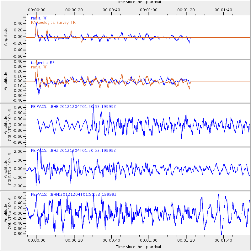
Signal To Noise
| Channel | StoN | STA | LTA |
| PE:PAGS: :BHZ:20121204T01:50:53.19999Z | 3.0177174 | 1.0058262E-6 | 3.3330696E-7 |
| PE:PAGS: :BHN:20121204T01:50:53.19999Z | 0.95050555 | 3.028995E-7 | 3.18672E-7 |
| PE:PAGS: :BHE:20121204T01:50:53.19999Z | 2.4538906 | 4.3895938E-7 | 1.7888303E-7 |
| Arrivals |
| Ps | |
| PpPs | |
| PsPs/PpSs | |


