You are here: Home > Network List > TA - USArray Transportable Network (new EarthScope stations) Stations List
> Station Y46A Houston, MS, USA > Earthquake Result Viewer
Y46A Houston, MS, USA - Earthquake Result Viewer

| Earthquake location: |
Southern Alaska |
| Earthquake latitude/longitude: |
61.2/-150.8 |
| Earthquake time(UTC): |
2012/12/04 (339) 01:42:48 GMT |
| Earthquake Depth: |
62 km |
| Earthquake Magnitude: |
5.6 MB, 5.8 MW, 5.7 MW |
| Earthquake Catalog/Contributor: |
WHDF/NEIC |
|
| Network: |
TA USArray Transportable Network (new EarthScope stations) |
| Station: |
Y46A Houston, MS, USA |
| Lat/Lon: |
33.88 N/88.86 W |
| Elevation: |
109 m |
|
| Distance: |
47.5 deg |
| Az: |
95.799 deg |
| Baz: |
324.66 deg |
| Ray Param: |
0.06975507 |
| Estimated Moho Depth: |
20.5 km |
| Estimated Crust Vp/Vs: |
2.10 |
| Assumed Crust Vp: |
6.201 km/s |
| Estimated Crust Vs: |
2.957 km/s |
| Estimated Crust Poisson's Ratio: |
0.35 |
|
| Radial Match: |
85.913376 % |
| Radial Bump: |
400 |
| Transverse Match: |
73.8996 % |
| Transverse Bump: |
400 |
| SOD ConfigId: |
488671 |
| Insert Time: |
2013-03-29 03:34:09.429 +0000 |
| GWidth: |
2.5 |
| Max Bumps: |
400 |
| Tol: |
0.001 |
|
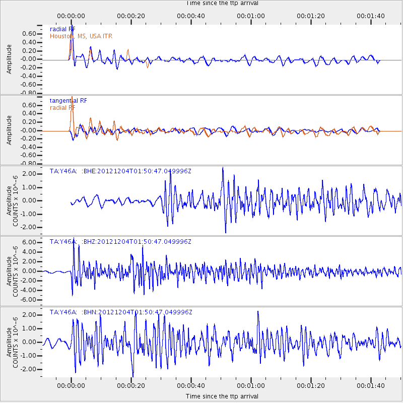
Signal To Noise
| Channel | StoN | STA | LTA |
| TA:Y46A: :BHZ:20121204T01:50:47.049996Z | 14.153372 | 2.480863E-6 | 1.7528424E-7 |
| TA:Y46A: :BHN:20121204T01:50:47.049996Z | 4.445875 | 1.1114265E-6 | 2.4999048E-7 |
| TA:Y46A: :BHE:20121204T01:50:47.049996Z | 5.125351 | 1.0175888E-6 | 1.9854032E-7 |
| Arrivals |
| Ps | 3.8 SECOND |
| PpPs | 9.8 SECOND |
| PsPs/PpSs | 14 SECOND |


