You are here: Home > Network List > TA - USArray Transportable Network (new EarthScope stations) Stations List
> Station Y44A Strider, Charleston, MS, USA > Earthquake Result Viewer
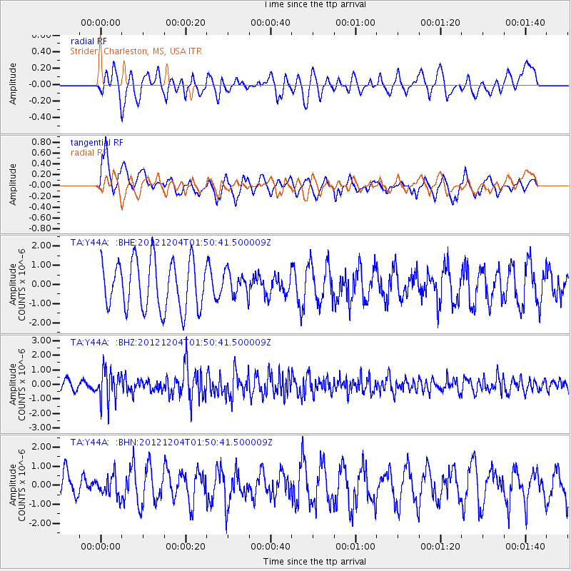
Y44A Strider, Charleston, MS, USA - Earthquake Result Viewer
*The percent match for this event was below the threshold and hence no stack was calculated.
| Earthquake location: |
Southern Alaska |
| Earthquake latitude/longitude: |
61.2/-150.8 |
| Earthquake time(UTC): |
2012/12/04 (339) 01:42:48 GMT |
| Earthquake Depth: |
62 km |
| Earthquake Magnitude: |
5.6 MB, 5.8 MW, 5.7 MW |
| Earthquake Catalog/Contributor: |
WHDF/NEIC |
|
| Network: |
TA USArray Transportable Network (new EarthScope stations) |
| Station: |
Y44A Strider, Charleston, MS, USA |
| Lat/Lon: |
33.96 N/90.21 W |
| Elevation: |
46 m |
|
| Distance: |
46.8 deg |
| Az: |
96.989 deg |
| Baz: |
324.717 deg |
| Ray Param: |
$rayparam |
*The percent match for this event was below the threshold and hence was not used in the summary stack. |
|
| Radial Match: |
37.20502 % |
| Radial Bump: |
383 |
| Transverse Match: |
64.493576 % |
| Transverse Bump: |
400 |
| SOD ConfigId: |
488671 |
| Insert Time: |
2013-03-29 03:34:15.097 +0000 |
| GWidth: |
2.5 |
| Max Bumps: |
400 |
| Tol: |
0.001 |
|
Signal To Noise
| Channel | StoN | STA | LTA |
| TA:Y44A: :BHZ:20121204T01:50:41.500009Z | 1.974313 | 1.0625487E-6 | 5.381865E-7 |
| TA:Y44A: :BHN:20121204T01:50:41.500009Z | 0.7657637 | 5.481997E-7 | 7.158862E-7 |
| TA:Y44A: :BHE:20121204T01:50:41.500009Z | 0.49617392 | 6.326323E-7 | 1.2750213E-6 |
| Arrivals |
| Ps | |
| PpPs | |
| PsPs/PpSs | |


