You are here: Home > Network List > GS - US Geological Survey Networks Stations List
> Station KAN13 Rinehart Farm > Earthquake Result Viewer
KAN13 Rinehart Farm - Earthquake Result Viewer
| Earthquake location: |
Rat Islands, Aleutian Islands |
| Earthquake latitude/longitude: |
52.0/178.4 |
| Earthquake time(UTC): |
2014/06/23 (174) 21:11:41 GMT |
| Earthquake Depth: |
107 km |
| Earthquake Magnitude: |
6.0 MB |
| Earthquake Catalog/Contributor: |
NEIC PDE/NEIC COMCAT |
|
| Network: |
GS US Geological Survey Networks |
| Station: |
KAN13 Rinehart Farm |
| Lat/Lon: |
37.01 N/97.48 W |
| Elevation: |
340 m |
|
| Distance: |
58.6 deg |
| Az: |
68.956 deg |
| Baz: |
313.829 deg |
| Ray Param: |
0.06245699 |
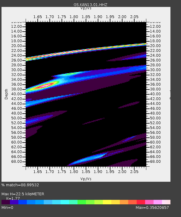
| Estimated Moho Depth: |
22.5 km |
| Estimated Crust Vp/Vs: |
1.77 |
| Assumed Crust Vp: |
6.483 km/s |
| Estimated Crust Vs: |
3.662 km/s |
| Estimated Crust Poisson's Ratio: |
0.27 |
|
| Radial Match: |
88.99532 % |
| Radial Bump: |
400 |
| Transverse Match: |
52.155426 % |
| Transverse Bump: |
278 |
| SOD ConfigId: |
3390531 |
| Insert Time: |
2019-04-12 10:54:35.076 +0000 |
| GWidth: |
2.5 |
| Max Bumps: |
400 |
| Tol: |
0.001 |
|

Signal To Noise
| Channel | StoN | STA | LTA |
| GS:KAN13:01:HHZ:20140623T21:20:55.430017Z | 1.5789714 | 2.2146613E-5 | 1.40259735E-5 |
| GS:KAN13:01:HHN:20140623T21:20:55.430017Z | 3.3788207 | 4.03892E-5 | 1.1953639E-5 |
| GS:KAN13:01:HHE:20140623T21:20:55.430017Z | 1.1251918 | 2.0190882E-5 | 1.7944392E-5 |
| Arrivals |
| Ps | 2.8 SECOND |
| PpPs | 9.2 SECOND |
| PsPs/PpSs | 12 SECOND |


