You are here: Home > Network List > TA - USArray Transportable Network (new EarthScope stations) Stations List
> Station F37A Hinrichs Farm, Grantsburg, WI, USA > Earthquake Result Viewer
F37A Hinrichs Farm, Grantsburg, WI, USA - Earthquake Result Viewer
*The percent match for this event was below the threshold and hence no stack was calculated.
| Earthquake location: |
Southern Alaska |
| Earthquake latitude/longitude: |
61.2/-150.8 |
| Earthquake time(UTC): |
2012/12/04 (339) 01:42:48 GMT |
| Earthquake Depth: |
62 km |
| Earthquake Magnitude: |
5.6 MB, 5.8 MW, 5.7 MW |
| Earthquake Catalog/Contributor: |
WHDF/NEIC |
|
| Network: |
TA USArray Transportable Network (new EarthScope stations) |
| Station: |
F37A Hinrichs Farm, Grantsburg, WI, USA |
| Lat/Lon: |
45.72 N/92.63 W |
| Elevation: |
296 m |
|
| Distance: |
36.5 deg |
| Az: |
87.932 deg |
| Baz: |
316.369 deg |
| Ray Param: |
$rayparam |
*The percent match for this event was below the threshold and hence was not used in the summary stack. |
|
| Radial Match: |
70.613365 % |
| Radial Bump: |
400 |
| Transverse Match: |
65.916145 % |
| Transverse Bump: |
400 |
| SOD ConfigId: |
488671 |
| Insert Time: |
2013-03-29 03:38:54.631 +0000 |
| GWidth: |
2.5 |
| Max Bumps: |
400 |
| Tol: |
0.001 |
|
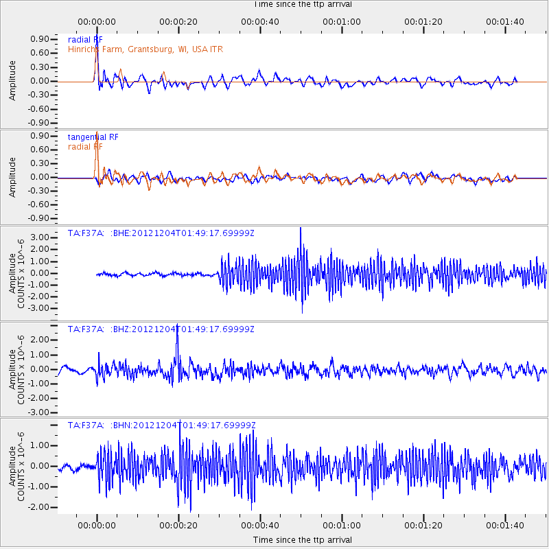
Signal To Noise
| Channel | StoN | STA | LTA |
| TA:F37A: :BHZ:20121204T01:49:17.69999Z | 2.7202744 | 4.2034543E-7 | 1.5452316E-7 |
| TA:F37A: :BHN:20121204T01:49:17.69999Z | 4.533516 | 6.3816873E-7 | 1.4076684E-7 |
| TA:F37A: :BHE:20121204T01:49:17.69999Z | 7.6324453 | 7.8316543E-7 | 1.0261003E-7 |
| Arrivals |
| Ps | |
| PpPs | |
| PsPs/PpSs | |


