You are here: Home > Network List > TA - USArray Transportable Network (new EarthScope stations) Stations List
> Station G42A Mountain, WI, USA > Earthquake Result Viewer
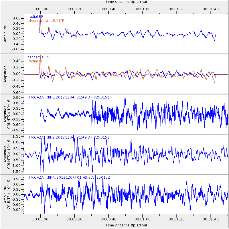
G42A Mountain, WI, USA - Earthquake Result Viewer
*The percent match for this event was below the threshold and hence no stack was calculated.
| Earthquake location: |
Southern Alaska |
| Earthquake latitude/longitude: |
61.2/-150.8 |
| Earthquake time(UTC): |
2012/12/04 (339) 01:42:48 GMT |
| Earthquake Depth: |
62 km |
| Earthquake Magnitude: |
5.6 MB, 5.8 MW, 5.7 MW |
| Earthquake Catalog/Contributor: |
WHDF/NEIC |
|
| Network: |
TA USArray Transportable Network (new EarthScope stations) |
| Station: |
G42A Mountain, WI, USA |
| Lat/Lon: |
45.24 N/88.43 W |
| Elevation: |
315 m |
|
| Distance: |
38.9 deg |
| Az: |
84.961 deg |
| Baz: |
317.003 deg |
| Ray Param: |
$rayparam |
*The percent match for this event was below the threshold and hence was not used in the summary stack. |
|
| Radial Match: |
58.925476 % |
| Radial Bump: |
400 |
| Transverse Match: |
58.45845 % |
| Transverse Bump: |
400 |
| SOD ConfigId: |
488671 |
| Insert Time: |
2013-03-29 03:39:27.898 +0000 |
| GWidth: |
2.5 |
| Max Bumps: |
400 |
| Tol: |
0.001 |
|
Signal To Noise
| Channel | StoN | STA | LTA |
| TA:G42A: :BHZ:20121204T01:49:37.725015Z | 2.997458 | 7.262696E-7 | 2.422952E-7 |
| TA:G42A: :BHN:20121204T01:49:37.725015Z | 2.5468273 | 4.4545084E-7 | 1.7490422E-7 |
| TA:G42A: :BHE:20121204T01:49:37.725015Z | 2.3330305 | 3.2545233E-7 | 1.3949769E-7 |
| Arrivals |
| Ps | |
| PpPs | |
| PsPs/PpSs | |


