You are here: Home > Network List > TA - USArray Transportable Network (new EarthScope stations) Stations List
> Station T47A Sharon Grove, KY, USA > Earthquake Result Viewer
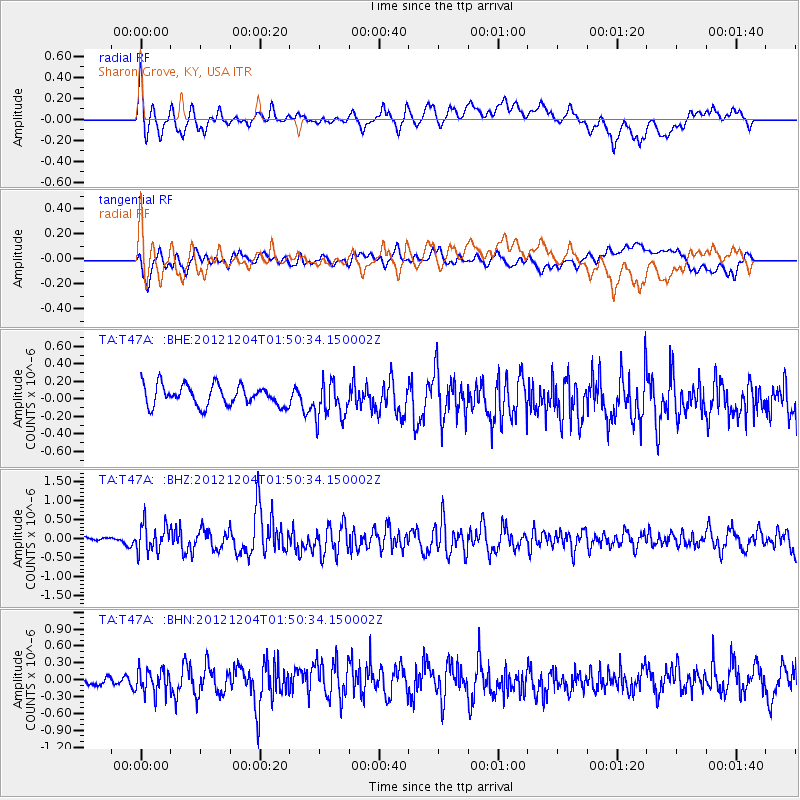
T47A Sharon Grove, KY, USA - Earthquake Result Viewer
*The percent match for this event was below the threshold and hence no stack was calculated.
| Earthquake location: |
Southern Alaska |
| Earthquake latitude/longitude: |
61.2/-150.8 |
| Earthquake time(UTC): |
2012/12/04 (339) 01:42:48 GMT |
| Earthquake Depth: |
62 km |
| Earthquake Magnitude: |
5.6 MB, 5.8 MW, 5.7 MW |
| Earthquake Catalog/Contributor: |
WHDF/NEIC |
|
| Network: |
TA USArray Transportable Network (new EarthScope stations) |
| Station: |
T47A Sharon Grove, KY, USA |
| Lat/Lon: |
36.99 N/87.11 W |
| Elevation: |
217 m |
|
| Distance: |
45.9 deg |
| Az: |
91.697 deg |
| Baz: |
322.857 deg |
| Ray Param: |
$rayparam |
*The percent match for this event was below the threshold and hence was not used in the summary stack. |
|
| Radial Match: |
63.50426 % |
| Radial Bump: |
400 |
| Transverse Match: |
48.68617 % |
| Transverse Bump: |
400 |
| SOD ConfigId: |
488671 |
| Insert Time: |
2013-03-29 03:41:03.087 +0000 |
| GWidth: |
2.5 |
| Max Bumps: |
400 |
| Tol: |
0.001 |
|
Signal To Noise
| Channel | StoN | STA | LTA |
| TA:T47A: :BHZ:20121204T01:50:34.150002Z | 2.2792063 | 3.5785055E-7 | 1.5700665E-7 |
| TA:T47A: :BHN:20121204T01:50:34.150002Z | 1.4887002 | 2.1459546E-7 | 1.4414955E-7 |
| TA:T47A: :BHE:20121204T01:50:34.150002Z | 1.8179816 | 2.1021444E-7 | 1.1563068E-7 |
| Arrivals |
| Ps | |
| PpPs | |
| PsPs/PpSs | |


