You are here: Home > Network List > TA - USArray Transportable Network (new EarthScope stations) Stations List
> Station X46A Booneville, MS, USA > Earthquake Result Viewer
X46A Booneville, MS, USA - Earthquake Result Viewer
| Earthquake location: |
Southern Alaska |
| Earthquake latitude/longitude: |
61.2/-150.8 |
| Earthquake time(UTC): |
2012/12/04 (339) 01:42:48 GMT |
| Earthquake Depth: |
62 km |
| Earthquake Magnitude: |
5.6 MB, 5.8 MW, 5.7 MW |
| Earthquake Catalog/Contributor: |
WHDF/NEIC |
|
| Network: |
TA USArray Transportable Network (new EarthScope stations) |
| Station: |
X46A Booneville, MS, USA |
| Lat/Lon: |
34.56 N/88.58 W |
| Elevation: |
150 m |
|
| Distance: |
47.1 deg |
| Az: |
95.017 deg |
| Baz: |
324.283 deg |
| Ray Param: |
0.07001844 |
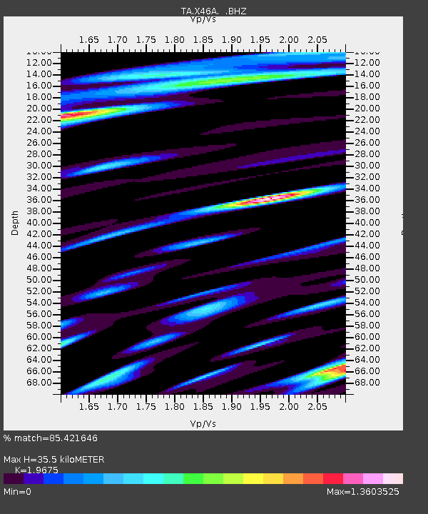
| Estimated Moho Depth: |
35.5 km |
| Estimated Crust Vp/Vs: |
1.97 |
| Assumed Crust Vp: |
6.38 km/s |
| Estimated Crust Vs: |
3.243 km/s |
| Estimated Crust Poisson's Ratio: |
0.33 |
|
| Radial Match: |
85.421646 % |
| Radial Bump: |
348 |
| Transverse Match: |
75.55301 % |
| Transverse Bump: |
400 |
| SOD ConfigId: |
488671 |
| Insert Time: |
2013-03-29 03:41:14.729 +0000 |
| GWidth: |
2.5 |
| Max Bumps: |
400 |
| Tol: |
0.001 |
|
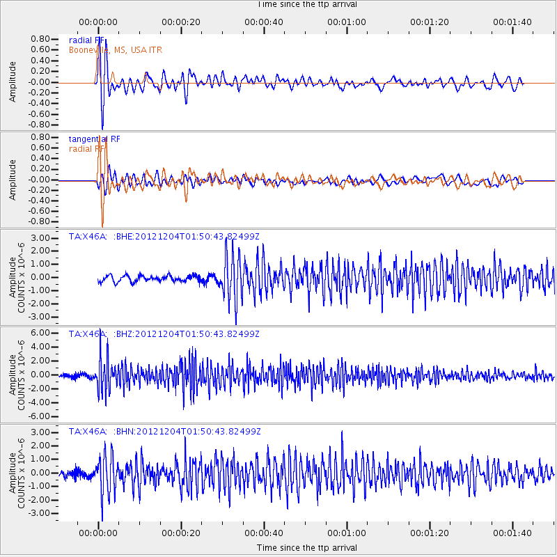
Signal To Noise
| Channel | StoN | STA | LTA |
| TA:X46A: :BHZ:20121204T01:50:43.82499Z | 11.606923 | 2.2943889E-6 | 1.9767418E-7 |
| TA:X46A: :BHN:20121204T01:50:43.82499Z | 7.426445 | 1.4273514E-6 | 1.9219848E-7 |
| TA:X46A: :BHE:20121204T01:50:43.82499Z | 7.430064 | 1.6855139E-6 | 2.2685052E-7 |
| Arrivals |
| Ps | 5.7 SECOND |
| PpPs | 16 SECOND |
| PsPs/PpSs | 21 SECOND |


