You are here: Home > Network List > TA - USArray Transportable Network (new EarthScope stations) Stations List
> Station X49A Woodville, AR, USA > Earthquake Result Viewer
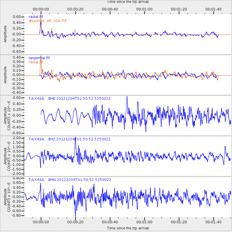
X49A Woodville, AR, USA - Earthquake Result Viewer
*The percent match for this event was below the threshold and hence no stack was calculated.
| Earthquake location: |
Southern Alaska |
| Earthquake latitude/longitude: |
61.2/-150.8 |
| Earthquake time(UTC): |
2012/12/04 (339) 01:42:48 GMT |
| Earthquake Depth: |
62 km |
| Earthquake Magnitude: |
5.6 MB, 5.8 MW, 5.7 MW |
| Earthquake Catalog/Contributor: |
WHDF/NEIC |
|
| Network: |
TA USArray Transportable Network (new EarthScope stations) |
| Station: |
X49A Woodville, AR, USA |
| Lat/Lon: |
34.51 N/86.33 W |
| Elevation: |
182 m |
|
| Distance: |
48.2 deg |
| Az: |
93.006 deg |
| Baz: |
324.203 deg |
| Ray Param: |
$rayparam |
*The percent match for this event was below the threshold and hence was not used in the summary stack. |
|
| Radial Match: |
64.06952 % |
| Radial Bump: |
400 |
| Transverse Match: |
61.341026 % |
| Transverse Bump: |
400 |
| SOD ConfigId: |
488671 |
| Insert Time: |
2013-03-29 03:41:38.180 +0000 |
| GWidth: |
2.5 |
| Max Bumps: |
400 |
| Tol: |
0.001 |
|
Signal To Noise
| Channel | StoN | STA | LTA |
| TA:X49A: :BHZ:20121204T01:50:52.525002Z | 2.3251371 | 4.465202E-7 | 1.9204037E-7 |
| TA:X49A: :BHN:20121204T01:50:52.525002Z | 2.9740882 | 2.2209413E-7 | 7.467638E-8 |
| TA:X49A: :BHE:20121204T01:50:52.525002Z | 1.3718796 | 1.9636484E-7 | 1.4313561E-7 |
| Arrivals |
| Ps | |
| PpPs | |
| PsPs/PpSs | |


