You are here: Home > Network List > TA - USArray Transportable Network (new EarthScope stations) Stations List
> Station V48A Smith Brothers Farm, Spring Hill, TN, USA > Earthquake Result Viewer
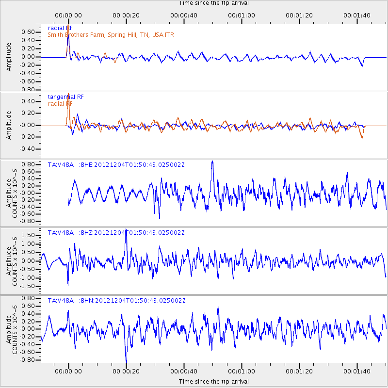
V48A Smith Brothers Farm, Spring Hill, TN, USA - Earthquake Result Viewer
*The percent match for this event was below the threshold and hence no stack was calculated.
| Earthquake location: |
Southern Alaska |
| Earthquake latitude/longitude: |
61.2/-150.8 |
| Earthquake time(UTC): |
2012/12/04 (339) 01:42:48 GMT |
| Earthquake Depth: |
62 km |
| Earthquake Magnitude: |
5.6 MB, 5.8 MW, 5.7 MW |
| Earthquake Catalog/Contributor: |
WHDF/NEIC |
|
| Network: |
TA USArray Transportable Network (new EarthScope stations) |
| Station: |
V48A Smith Brothers Farm, Spring Hill, TN, USA |
| Lat/Lon: |
35.74 N/86.82 W |
| Elevation: |
278 m |
|
| Distance: |
47.0 deg |
| Az: |
92.473 deg |
| Baz: |
323.56 deg |
| Ray Param: |
$rayparam |
*The percent match for this event was below the threshold and hence was not used in the summary stack. |
|
| Radial Match: |
62.70973 % |
| Radial Bump: |
378 |
| Transverse Match: |
51.723114 % |
| Transverse Bump: |
337 |
| SOD ConfigId: |
488671 |
| Insert Time: |
2013-03-29 03:41:48.142 +0000 |
| GWidth: |
2.5 |
| Max Bumps: |
400 |
| Tol: |
0.001 |
|
Signal To Noise
| Channel | StoN | STA | LTA |
| TA:V48A: :BHZ:20121204T01:50:43.025002Z | 2.693932 | 5.244273E-7 | 1.9466984E-7 |
| TA:V48A: :BHN:20121204T01:50:43.025002Z | 1.4133154 | 2.0568403E-7 | 1.45533E-7 |
| TA:V48A: :BHE:20121204T01:50:43.025002Z | 1.7576827 | 2.6678777E-7 | 1.5178381E-7 |
| Arrivals |
| Ps | |
| PpPs | |
| PsPs/PpSs | |


