You are here: Home > Network List > TA - USArray Transportable Network (new EarthScope stations) Stations List
> Station 149A Jones, AL, USA > Earthquake Result Viewer
149A Jones, AL, USA - Earthquake Result Viewer
| Earthquake location: |
Southern Alaska |
| Earthquake latitude/longitude: |
61.2/-150.8 |
| Earthquake time(UTC): |
2012/12/04 (339) 01:42:48 GMT |
| Earthquake Depth: |
62 km |
| Earthquake Magnitude: |
5.6 MB, 5.8 MW, 5.7 MW |
| Earthquake Catalog/Contributor: |
WHDF/NEIC |
|
| Network: |
TA USArray Transportable Network (new EarthScope stations) |
| Station: |
149A Jones, AL, USA |
| Lat/Lon: |
32.60 N/86.79 W |
| Elevation: |
138 m |
|
| Distance: |
49.6 deg |
| Az: |
94.891 deg |
| Baz: |
325.186 deg |
| Ray Param: |
0.068441644 |
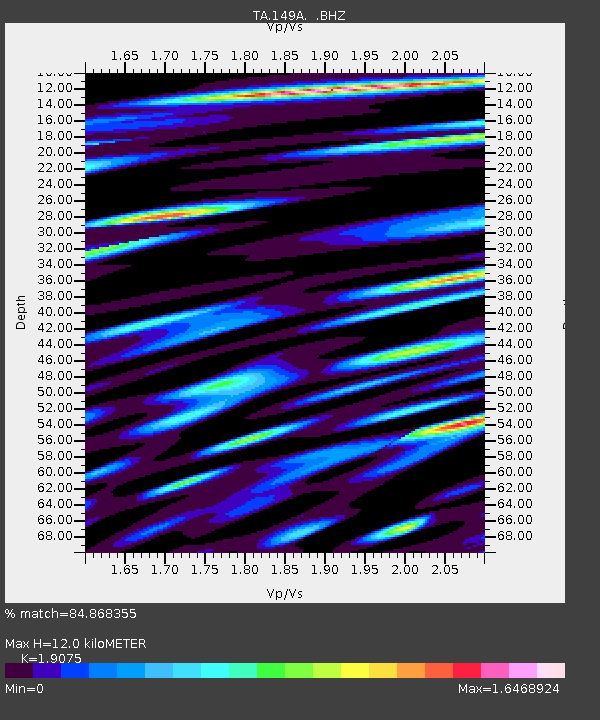
| Estimated Moho Depth: |
12.0 km |
| Estimated Crust Vp/Vs: |
1.91 |
| Assumed Crust Vp: |
6.565 km/s |
| Estimated Crust Vs: |
3.441 km/s |
| Estimated Crust Poisson's Ratio: |
0.31 |
|
| Radial Match: |
84.868355 % |
| Radial Bump: |
400 |
| Transverse Match: |
72.15117 % |
| Transverse Bump: |
400 |
| SOD ConfigId: |
488671 |
| Insert Time: |
2013-03-29 03:42:33.378 +0000 |
| GWidth: |
2.5 |
| Max Bumps: |
400 |
| Tol: |
0.001 |
|

Signal To Noise
| Channel | StoN | STA | LTA |
| TA:149A: :BHZ:20121204T01:51:02.725015Z | 11.263825 | 1.1193147E-6 | 9.937252E-8 |
| TA:149A: :BHN:20121204T01:51:02.725015Z | 7.2378902 | 8.4630926E-7 | 1.16927616E-7 |
| TA:149A: :BHE:20121204T01:51:02.725015Z | 5.2600565 | 6.663661E-7 | 1.2668421E-7 |
| Arrivals |
| Ps | 1.8 SECOND |
| PpPs | 5.0 SECOND |
| PsPs/PpSs | 6.8 SECOND |


