You are here: Home > Network List > TA - USArray Transportable Network (new EarthScope stations) Stations List
> Station W53A Cullowhee, NC, USA > Earthquake Result Viewer
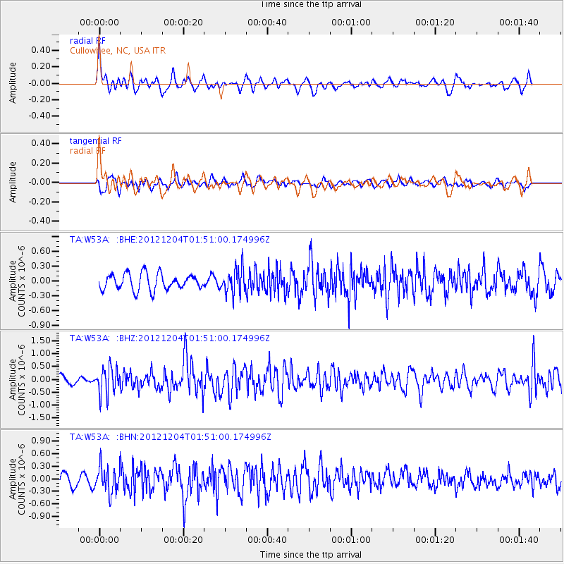
W53A Cullowhee, NC, USA - Earthquake Result Viewer
*The percent match for this event was below the threshold and hence no stack was calculated.
| Earthquake location: |
Southern Alaska |
| Earthquake latitude/longitude: |
61.2/-150.8 |
| Earthquake time(UTC): |
2012/12/04 (339) 01:42:48 GMT |
| Earthquake Depth: |
62 km |
| Earthquake Magnitude: |
5.6 MB, 5.8 MW, 5.7 MW |
| Earthquake Catalog/Contributor: |
WHDF/NEIC |
|
| Network: |
TA USArray Transportable Network (new EarthScope stations) |
| Station: |
W53A Cullowhee, NC, USA |
| Lat/Lon: |
35.17 N/83.16 W |
| Elevation: |
1180 m |
|
| Distance: |
49.2 deg |
| Az: |
89.693 deg |
| Baz: |
323.817 deg |
| Ray Param: |
$rayparam |
*The percent match for this event was below the threshold and hence was not used in the summary stack. |
|
| Radial Match: |
61.367245 % |
| Radial Bump: |
400 |
| Transverse Match: |
56.72965 % |
| Transverse Bump: |
400 |
| SOD ConfigId: |
488671 |
| Insert Time: |
2013-03-29 03:45:21.211 +0000 |
| GWidth: |
2.5 |
| Max Bumps: |
400 |
| Tol: |
0.001 |
|
Signal To Noise
| Channel | StoN | STA | LTA |
| TA:W53A: :BHZ:20121204T01:51:00.174996Z | 2.8827093 | 5.156897E-7 | 1.7889064E-7 |
| TA:W53A: :BHN:20121204T01:51:00.174996Z | 1.9952126 | 3.124277E-7 | 1.5658867E-7 |
| TA:W53A: :BHE:20121204T01:51:00.174996Z | 1.5719221 | 2.5553595E-7 | 1.6256273E-7 |
| Arrivals |
| Ps | |
| PpPs | |
| PsPs/PpSs | |


