You are here: Home > Network List > TA - USArray Transportable Network (new EarthScope stations) Stations List
> Station V49A McMinnville, TN, USA > Earthquake Result Viewer
V49A McMinnville, TN, USA - Earthquake Result Viewer
*The percent match for this event was below the threshold and hence no stack was calculated.
| Earthquake location: |
Southern Alaska |
| Earthquake latitude/longitude: |
61.2/-150.8 |
| Earthquake time(UTC): |
2012/12/04 (339) 01:42:48 GMT |
| Earthquake Depth: |
62 km |
| Earthquake Magnitude: |
5.6 MB, 5.8 MW, 5.7 MW |
| Earthquake Catalog/Contributor: |
WHDF/NEIC |
|
| Network: |
TA USArray Transportable Network (new EarthScope stations) |
| Station: |
V49A McMinnville, TN, USA |
| Lat/Lon: |
35.77 N/85.90 W |
| Elevation: |
329 m |
|
| Distance: |
47.4 deg |
| Az: |
91.633 deg |
| Baz: |
323.524 deg |
| Ray Param: |
$rayparam |
*The percent match for this event was below the threshold and hence was not used in the summary stack. |
|
| Radial Match: |
53.571888 % |
| Radial Bump: |
400 |
| Transverse Match: |
47.012337 % |
| Transverse Bump: |
400 |
| SOD ConfigId: |
488671 |
| Insert Time: |
2013-03-29 03:45:44.226 +0000 |
| GWidth: |
2.5 |
| Max Bumps: |
400 |
| Tol: |
0.001 |
|
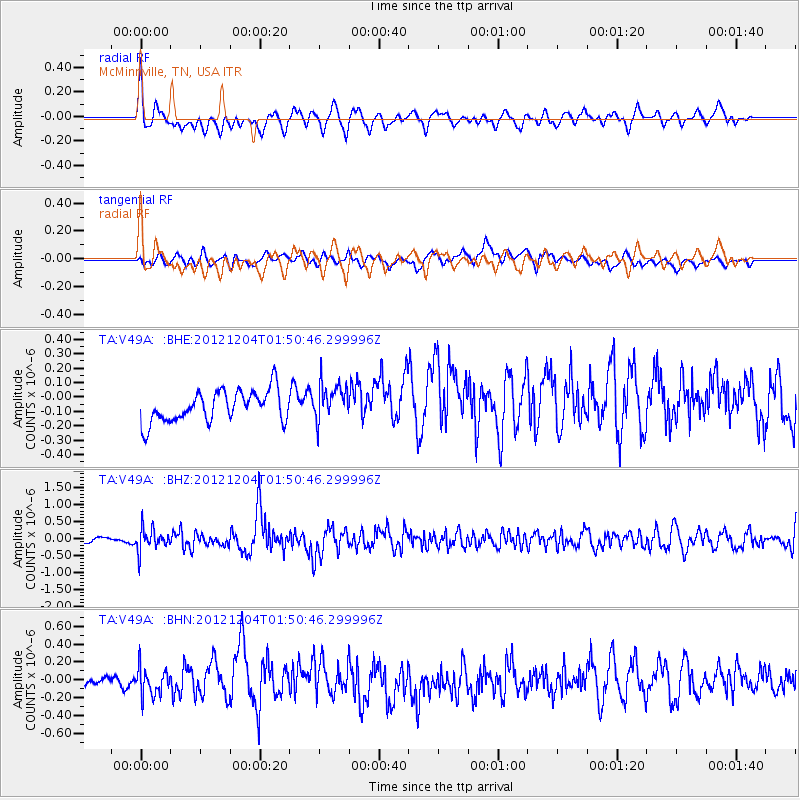
Signal To Noise
| Channel | StoN | STA | LTA |
| TA:V49A: :BHZ:20121204T01:50:46.299996Z | 2.9789371 | 3.2495353E-7 | 1.09083715E-7 |
| TA:V49A: :BHN:20121204T01:50:46.299996Z | 1.3520287 | 1.5051504E-7 | 1.1132531E-7 |
| TA:V49A: :BHE:20121204T01:50:46.299996Z | 1.183833 | 1.2758575E-7 | 1.0777343E-7 |
| Arrivals |
| Ps | |
| PpPs | |
| PsPs/PpSs | |


